


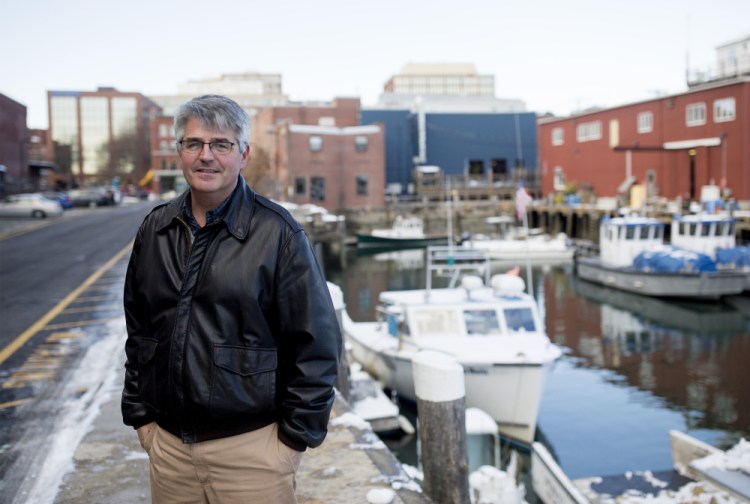
Earlier this month, during the king tide, Bill Needelman led a walking tour of Portland’s Bayside neighborhood to show Portlanders what impact the highest tides of the year have on the city’s waterfront. We wanted to know more about king tides and Needelman’s role as the city’s first waterfront coordinator, a job that includes managing what happens when water starts pooling around the city’s storm drains as climate change literally increases sea levels.
MANY HATS: Needelman has a lot of duties beyond tracking the impacts of climate change on the city’s waterfront. He staffs Portland Fish Pier, helps plan open space and infrastructure projects on the waterfront and serves as the liaison when local policy issues overlap with the state and federal governments. Beyond these, he works with private pier owners and manages issues that arise with the city’s piers.
WORKING WATERFRONT: How many piers are we talking about? “The city owns two significant properties that are real working piers: The Ocean Gateway and Maine State Pier complex, and the city Fish Pier.” Needelman also oversees municipal interactions with about 15 privately owned piers as well as marinas, like the one in East Deering. In short, a lot of territory, different entities and moving parts, from condos to restaurants and seafood processors. “We have a long tradition of private ownership on Portland’s waterfront. That’s one of the things that makes it so unique. We have industrial facilities under private ownership that support a number of marine and nonmarine resources and have the ability to load and unload a commercial vessel.”
THE PRINCE OF KING TIDES: What do king tides have to do with that? “Sea level rise and climate change overlaps with everything on the waterfront, so it has become one of my program elements.” After all, Portland is surrounded with water, whether it be Casco Bay, the Fore River or Back Cove. Or the puddles that appear in Bayside when rain and high tide coincide.
FIRST HIRE: Needelman was with the city’s planning office for 14 years before becoming the city’s first waterfront coordinator in 2013. Then-City Manager Mark Rees led the charge to hire someone whose principal job would be to work on the city’s waterfront economic interests. As a planner, Needelman had worked on master planning, historic preservation and waterfront developments, like the Gulf of Maine Research Institute’s laboratory and research center, which opened in 2005 (he’s proud of how that turned out). His undergraduate degree from Boston College was in geology, and he has a master’s in community development and planning from the Muskie School at the University of Southern Maine, a degree he worked toward one or two night classes at a time while working full time. The flexibility and proximity offered by USM was “an absolute godsend.”
LANGUAGE SKILLS: The Portland native has commercial fishing in his family background, cousins who live on Chebeague, and in his own early career, he worked construction jobs that took him to the islands, often to Little Diamond. “I would get on a boat as part of my commute every day.” He knew the tides, the ferry schedules. “It has always been part of my experience to interact with Casco Bay. It was always there. I knew the language.”
PEOPLE PERKS: What’s his favorite part of the job? The interactions, which are nearly as varied as Maine weather. “I get to speak with the representatives of Eimskip, the Icelandic steamship company, and then go right next door and talk to the folks who are harvesting lobster or herring and then work with the street artists who are serving our cruise ship customers. And then step right out of that meeting and speak to the folks who are giving sailing lessons through SailMaine. The one thing that they all have in common is their relationship with the water. That is character defining.”
WALKING THE WALK: For several years Needelman has been organizing city staff walks during astronomical tides. “I describe them as a scavenger hunt for water.” The best place to go looking is the Bayside neighborhood, since geographically it is one of the lower elevations in the city, “and it is widely recognized as vulnerable to flooding.” The Dec. 5 king tide walk was organized by Jan Piribeck, an art professor at the University of Southern Maine who has organized art projects around climate change.
RISKY BUSINESS: The idea is to use the tides as “an opportunity to better understand our risk as a coastal community.” They find water in catch basins, ponding in roadways and in all the usual places, like the intersection of Somerset and Franklin streets. Or as you may know it, that corner near Whole Foods supermarket that flooded so badly in September 2015. Was that a king tide? Astronomically high, yes, Needelman said, but also one that coincided with a torrential downpour in the middle of the day. Some king tides come and go in the middle of the night, he said, without much notice from the (sleeping) public.
RECIPE FOR FLOODING: Those mega-puddles, or “nuisance flooding,” that swamped cars were the result of tide and rain hitting when storm water pipes that let out into Back Cove were below the surface of the ocean. “There was nowhere for the water to go.” Needelman coordinates with the Public Works Department to mitigate potential future flooding. They keep the storm drains clean and street-sweep steadily. “That is constant work that they do to make sure that flooding events are as small as possible.” As waterfront coordinator, Needelman is never far from a tide chart so they can be prepared.
HISTORY HELPS: Looking back is useful. “We have great tide data on Portland Harbor, almost 100 years of tide data from Maine State Pier.” Needelman calls the 1978 blizzard “the signature flooding event.” The storm surge was several feet, and Needelman, then an eighth-grader, remembers it well. “We all got a few days off from school.” Events like that, which resulted in some “knee-high” flooding and damage to the piers and wharfs, particularly near J’s Oyster, are the maps for rising sea levels in the future. “I think it is inevitable,” he said. Past hurricanes (Bob, Gloria) and storms also serve as teaching tools. “We use them as an indication of what sea level will look like in the future.”
NO GLOOM AND DOOM: On this latest walking tour, Needelman met with a receptive audience. “I think what was noteworthy was how engaged people were. It wasn’t a scary event.” He thinks that’s the right attitude, as coastal dwellers learn to accept flooding as more routine, as something they can prepare for, not an outlier linked to big storms and astronomical tides. “We don’t need to be afraid of the water. We need to respect the water.”
Correction: This story was updated at 3:37 p.m. on Dec. 20, 2017 to correct the spelling of Bill Needelman’s last name.
Send questions/comments to the editors.

Success. Please wait for the page to reload. If the page does not reload within 5 seconds, please refresh the page.
Enter your email and password to access comments.
Hi, to comment on stories you must . This profile is in addition to your subscription and website login.
Already have a commenting profile? .
Invalid username/password.
Please check your email to confirm and complete your registration.
Only subscribers are eligible to post comments. Please subscribe or login first for digital access. Here’s why.
Use the form below to reset your password. When you've submitted your account email, we will send an email with a reset code.