


RICHMOND — The risk of flooding from Kennebec River ice jamming up this year is normal, authorities armed with an ice auger and a chisel determined Tuesday.
Despite this winter’s brutal cold, the thickness and makeup of ice in the river is not cause for additional concerns about ice chunks jamming in the river and causing flooding this spring.
Additional Photos
Greg Stewart, data section chief of the U.S. Geological Survey, measured the thickness of river ice just above the Richmond-Dresden bridge and found it ranged from 1 to 1.6 feet at six spots between the shores of Richmond and Dresden.
That’s normal for this time of year, he said.
The depth of black ice — sheet ice that is harder and more difficult to break up — ranged from 0.4 feet to 0.8 feet in the same six holes. The rest was white, or snow ice, which is made up of various materials including snow, re-frozen ice, and rain water that froze on the river. That layer is softer and more likely to break up.
“There’s more snow ice than black ice. That’s good news for flood potential,” Stewart said.
The ice thickness is only one of many factors considered in determining the flood risk. Other factors include water and air temperatures, rainfall and the amount of snow pack that eventually will melt and flow into the state’s streams and rivers.
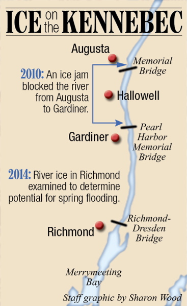
The River Flow Advisory Commission meets Thursday to discuss data collected about ice and snow pack thickness and other factors to try to determine the likelihood of flooding this year. The worst flooding in recent memory occurred in January 2010 when an ice jam more than a mile long flooded Augusta and Hallowell’s downtowns, filling streets, parking lots and basements with icy water.
On Tuesday, Bob Albert, chief warrant officer and ice condition manager for the U.S. Coast Guard, based in South Portland, came along “to learn what we’re up against.”
The officials plan to take the data collected Tuesday between Richmond and Dresden to Thursday’s River Flow Advisory Commission meeting.
Albert oversees and plans operations for Coast Guard ice-breaking vessels, which, in most recent years, have come up the river to the Pearl Harbor Remembrance Bridge in Gardiner to break ice to prevent flooding. The cutters can’t travel any farther north because they can’t pass under the bridge.
Albert said it will be up to the Maine Emergency Management Agency to determine whether the icebreakers are needed this year. If MEMA officials ask the Coast Guard to come break up the ice, Albert said, it will do so.
Stewart, after measuring the ice thickness, told Albert, the ice “won’t be as strong as it could be. I think you guys will be able to push right through it.”
The icebreakers weren’t needed last year, as the ice went out to sea on its own anyway in the spring, as the weather cooperated and the ice melted and drifted away without any flood-causing ice jams.
“Last year it rotted and went to the sea on its own, with no flooding risk,” Albert said. “That’s a good thing. Our role right now is to maintain readiness.”
Keith Edwards — 621-5647 kedwards@centralmaine.com
Send questions/comments to the editors.

Success. Please wait for the page to reload. If the page does not reload within 5 seconds, please refresh the page.
Enter your email and password to access comments.
Hi, to comment on stories you must . This profile is in addition to your subscription and website login.
Already have a commenting profile? .
Invalid username/password.
Please check your email to confirm and complete your registration.
Only subscribers are eligible to post comments. Please subscribe or login first for digital access. Here’s why.
Use the form below to reset your password. When you've submitted your account email, we will send an email with a reset code.