

A 16-foot-long great white shark was tracked over the holiday weekend off the Delaware coast, experts said, and she has been seen recently in the waters off Chincoteague and Assateague islands in Virginia and Maryland.
Ocearch.org, a shark research organization, tracked the shark – which has been named Mary Lee – on Sunday within two miles of Cape Henlopen State Park in Lewes, Delaware.
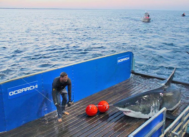
An up-close look at Mary Lee, the 16-foot-long great white shark, that was pinged off Delaware and New Jersey’s coast over the Memorial Day weekend. Photo courtesy of Ocearch.org
Mary Lee, who weighs about 3,500 pounds, was also later spotted that day along the Cape May, New Jersey, shore. Like any popular shark these days, she has her own Twitter handle.
Ocearch has tracked about 300 sharks over the years. It has been tracking Mary Lee since she was tagged in 2012 with a GPS-like tracking device. When one of their tagged sharks is spotted, they refer to it as a “ping.”
Mary Lee has been tracked several times over the years along the East Coast. Last week, the shark had a ping along Assateague Island and another near Chincoteague.
Other great white sharks have been tracked along the Delaware and Virginia coasts, but this one is larger than others that have gained social media fame. There was Yeti, an 11-foot, 960-pound great white that was spotted in November off the coasts of Delaware and Virginia Beach. And there was Miss Costa, a 12½-foot long, 1,700-pound great white that was tracked in October off the coast east of the Virginia-North Carolina border.
The information scientists glean once a shark is tagged is important, they said, to understanding more about the creatures and how to preserve their habitat.
Tagging a shark, however, is not easy.
.@MaryLeeShark, a very popular great white, visited the Jersey Shore this weekend with a friend. More here: https://t.co/eUUYtHYkLr pic.twitter.com/ExbKqnoLFM
— SNJ Today (@SNJToday) May 30, 2017
Crews use a 126-foot boat and a special hydraulic lift to get access to the animal for a brief time. In about 15 minutes, they take blood and genetic samples, and attach a transmitter to the shark’s dorsal fin.
That transmitter sends a signal to satellites and works much like a GPS tracker. It allows scientists to follow the shark’s movements. When the shark swims near the surface, which usually isn’t often, the transmitter sends a signal that gets picked up by a satellite. Scientists can then see the shark’s location in near real time, experts said.
Ocearch has tracked about 300 sharks over the past decade. It uses the information to help understand the sharks’ habitats, including where they feed – and when – and where they give birth.
Typically, the tags placed on a shark last about five years. Experts who follow the sharks with Ocearch have said the material they gather is “critical” for protecting the sharks.
Copy the Story LinkSend questions/comments to the editors.

Success. Please wait for the page to reload. If the page does not reload within 5 seconds, please refresh the page.
Enter your email and password to access comments.
Hi, to comment on stories you must . This profile is in addition to your subscription and website login.
Already have a commenting profile? .
Invalid username/password.
Please check your email to confirm and complete your registration.
Only subscribers are eligible to post comments. Please subscribe or login first for digital access. Here’s why.
Use the form below to reset your password. When you've submitted your account email, we will send an email with a reset code.