


The quote by J.R.R. Tolkien “Not all those who wander are lost” could definitely apply to Ryan Linn.
Shortly after the Belfast native graduated from Vassar College in 2006, Linn hiked the Appalachian Trail with no clear idea what he would do for a career.
“What I envisioned was seasonal work, doing a thru-hike, and other seasonal work,” said Linn, 34. “I never had a coherent plan. I never envisioned being in business. When this started, I thought it would be some spare change in between seasonal work.”
“This” turned out to be an unlikely success story for Linn who, with two partners, runs a company called Atlas Guides – makers of map-based navigational apps for smartphones. Not bad for a history major with no academic or professional training in computer science.
Unlike the majority of hiking app companies, this one focuses on the finer details of backpacking hikes, as opposed to day hikes.
Three years after completing the AT, Linn set out to hike the 2,600-mile Pacific Crest Trail. It was along the trail in Oregon he met fellow hiker Paul Bodnar.
Bodnar was working on a pocket guide for the PCT after leaving a job as a chemist at a pharmaceutical company. As Bodnar and Linn looked around at how many people suddenly were using iPhones on the trail, they talked about developing a hiking app.
They hiked through two states and across 1,300 miles and shared ideas.
When they finished the trail and went home, they worked together on a Pacific Crest Trail trail app for the iPhone.
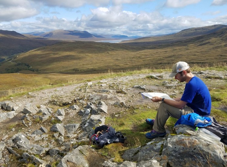
It was while hiking the Pacific Crest Trail in Oregon that Ryan Linn met up with Paul Bodnar. That was the beginning of Atlas Guides, which now provides map-based navigational smartphone guides for hiking and cycling adventures. Staff photo by Derek Davis
Linn took a day job at Eastern Mountain Sports in Keene, New Hampshire, studying IOS development at night. In junior high, computer science came easily to him. So, at age 26, Linn researched online how to program on a smartphone.
“There is actually an amazing amount of information on the Internet about computer programing. I basically started from scratch,” said Linn, who now lives in Portland.
Linn and Bodnar finished developing the platform in March 2011, and rolled out their PCT app a year later – Guthook. That was Linn’s name on the Appalachian Trail and the title of his popular blog. A year later, they were joined by Bodnar’s wife, Alice, who left her job at a law firm after testing the Guthook app on the Pacific Crest Trail.
“We moved to this tiny cabin in Idyllwild, California, and I taught myself Android programming,” she said.
Alice Bodnar’s Android app for the Pacific Crest Trail was launched in April 2013. Soon, the trio worked on putting out similar apps for the Appalachian Trail, the John Muir Trail and the 165-mile Tahoe Rim Trail.
And people wanted more.
The company that became Atlas Guides, “makers of Guthook guides,” expanded its offerings.
Their apps show trails and sections of trails with a waypoint showing where a user is on the trail, and what special features there are along the trail, such as sanctioned campsites, water sources, outhouses and points of interest. Hikers also can add notes for other hikers about such things such as blow-downs, preferred water sources or scenic overlooks.
The apps also help trail organizations, like the Appalachian Trail Conservancy, get out important messages, such as Baxter State Park’s request that thru-hikers on the Appalachian Trail finish on Mount Katahdin with a group of 10 or less.
Matthew Nelson, the executive director of the Arizona Trail Association, said Atlas Guides app for the Arizona Trail, which came out in 2015, has been embraced by many of the trail’s users – as well as the association’s staff of eight employees, five regional stewards and about 2,400 volunteers.
“There is 100-percent use,” Nelson said of his staff. “There was one administrative person who did not use it. But she ended up buying it because she fielded enough questions from the public about it. One of the things I appreciate is Ryan and Alice and Paul want to benefit trail users. As a result, it’s easy to use, easy to update and highly functional.”
Susan Herndon-Powell, who gathered waypoints for Atlas Guides on the Appalachian Trail in 2012, said the app is used by many hikers along the trail in Virginia, where Herndon-Powell lives and leads hikes for the local Appalachian Trail club.
“I spend a good bit of time on the trail,” Herndon-Powell said. “I’m on the board of directors at the (Roanoke Appalachian Trail Club) and work with a lot of different hikers. I always ask what navigation system they’re using, and a lot of folks are using Guthook. Guthook tells you where you are, which is helpful as you plan your day, knowing how many more miles you have.”
Today, Atlas Guides has trail apps for 20 trails or trail networks in the United States and apps for trails in five other countries.
In the past few months they hired their first two employees to handle social media and marketing and assist with new app designs.
While they won’t say how profitable the company is, Paul Bodnar, who now lives in Flagstaff, Arizona, with his wife said: “Now we are paying some serious taxes.”
And now Bodnar laughs when asked about collaborating in 2010 with a fairly recent college grad with no idea what he would do next.
“He seemed like a smart guy,” said Bodnar, 47. “The important part was I felt we could solve problems together. And if you can work with someone like that, that’s more important than finding a programmer. Ryan can actually accomplish things.
“He was 26. But he was very knowledgeable. And he wasn’t afraid to voice his opinion. I think it’s important to work with people who can be open and express new ideas. I was lucky to find him.”
Send questions/comments to the editors.

Success. Please wait for the page to reload. If the page does not reload within 5 seconds, please refresh the page.
Enter your email and password to access comments.
Hi, to comment on stories you must . This profile is in addition to your subscription and website login.
Already have a commenting profile? .
Invalid username/password.
Please check your email to confirm and complete your registration.
Only subscribers are eligible to post comments. Please subscribe or login first for digital access. Here’s why.
Use the form below to reset your password. When you've submitted your account email, we will send an email with a reset code.