

WAVELAND, Miss. — Hurricane Sally, one of four storms churning simultaneously in the Atlantic, closed in on the Gulf Coast on Monday with rapidly strengthening winds of at least 100 mph and heavy rain as forecasters warned of “potentially historic” flooding and governors declared states of emergency.
The slow-moving storm was forecast to brush the southeastern tip of Louisiana and then blow ashore late Tuesday or early Wednesday near the Mississippi-Alabama state line, the National Hurricane Center said. Hurricane warnings stretched from Morgan City, Louisiana, to Navarre, Florida.
President Trump issued an emergency declaration for parts of Louisiana and Mississippi on Monday, an action that authorizes federal emergency officials to coordinate disaster relief efforts and provide emergency assistance to the affected areas.
Alabama Gov. Kay Ivey asked the president to do the same for her state after the National Weather Service in Mobile warned of the increasing likelihood of “dangerous and potentially historic flooding.” The weather service forecast that waters could rise as much as 9 feet above ground in large parts of the Mobile metro area. With a population of 400,000 people, it is the largest metro area along the Gulf Coast between New Orleans and Tampa, Florida. Some businesses in Mobile placed sandbags at their entrances in preparation.

Kim Miller and Monty Graham open their truck bed and began loading up sandbags along U.S. 90 in preparation for Tropical Storm Sally on Sunday in Gulfport, Miss. Alyssa Newton/The Sun Herald via Associated Press
Florida Gov. Ron DeSantis declared a state of emergency in the Panhandle’s westernmost counties, Escambia and Santa Rosa as the hurricane’s outer bands began to lash the area. All along the storm-weary Gulf Coast, residents rushed to buy bottled water and other supplies ahead of the hurricane, which powered up to a Category 2 in the afternoon. Forecasters said sustained winds could reach 110 mph, just below Category 3 strength, by landfall.
Seawater and sand swept onto roads on one end of Dauphin Island off the coast of Alabama, washing away several cars, Dauphin Island Mayor Jeff Collier said. He said about a dozen people had to be evacuated by Humvee.
In coastal Mississippi, water spilled onto roads, lawns and docks well before the storm’s arrival. All 12 casinos were ordered to shut down Monday afternoon and Gov. Tate Reeves urged residents of low-lying areas to prepare to evacuate.
“This is the real deal, and it deserves your attention,” Reeves wrote on Twitter. “Be smart. Prepare for worst. Pray for the best,” he said.
Reeves said Sally could dump up to 20 inches of rain on the southern part of the state. Shelters opened, but officials urged people who are evacuating to stay with friends or relatives or in hotels, if possible, because of the coronavirus.
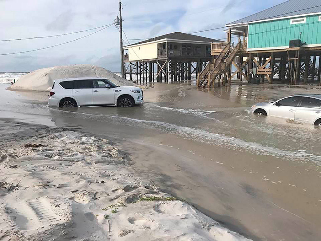
This photo provided by Dauphin Island Mayor Jeff Collier shows cars stranded in the sand as flooding continues on Dauphin Island, Ala., on Monday with Hurricane Sally closing in on the Gulf Coast. Jeff Collier via AP
The town of Kiln, Mississippi, where many homes sit high on stilts along the Jourdan River and its tributaries, was under a mandatory evacuation order, and it appeared most residents obeyed.
“It would be dumb to stay here,” said Michael “Mac” Mclaughlin, 72, a retiree who planned to ride out the storm in New Orleans with his girlfriend. He said his home was built in 2014 to withstand hurricanes, “but I just don’t want to be here when the water’s that deep and be stranded. That wouldn’t be smart.”
Jeremy Burke lifted things off the floor in case of flooding in his Bay Books bookstore in the Old Town neighborhood of Bay St. Louis, a popular weekend getaway from New Orleans, about 60 miles to the west.
“It’s turning into a ghost town,” he said.
Sally has lots of company during what has become one of the busiest hurricane seasons in history — so busy that forecasters have almost run through the alphabet of names with 2 1/2 months still to go.

This satellite image provided by the NOAA shows five tropical cyclones churning in the Atlantic basin Monday afternoon. The storms, from left, are Hurricane Sally over the Gulf of Mexico, Hurricane Paulette over Bermuda, the remnants of Tropical Storm Rene, and Tropical Storms Teddy and Vicky. NOAA via Associated Press
For only the second time on record, forecasters said, five tropical cyclones swirled simultaneously in the Atlantic basin at one point Monday. The last time that happened was in 1971.
In addition to Sally were Hurricane Paulette, which passed over a well-fortified Bermuda on Monday and was expected to peel harmlessly out into the North Atlantic; and Tropical Storms Rene, Teddy and Vicky, all of them out at sea and unlikely to threaten land this week, if at all. Rene was downgraded to a trough of low pressure Monday evening.
Sally was about 135 miles south of Biloxi, Mississippi, on Monday night, moving at 6 mph. The hurricane’s sluggish pace could give it more time to drench the Mississippi Delta with rain and storm surge. Storm surge warnings stretched from Port Fourchon in Louisiana to the line between Okaloosa and Walton counties in Florida. Also included: lakes Pontchartrain, Maurepas and Borgne in the New Orleans area and Mobile Bay in Alabama.
Sally was moving west-northwest Monday night but forecasters expected it to turn slightly east. People in New Orleans worried that Sally would pose the latest test for pumps used in the low-lying city’s century-old drainage system.
In eastern New Orleans, drainage canals were lowered in anticipation of torrential rains, Mayor LaToya Cantrell said. New Orleans police went on 12-hour shifts, and rescue boats, barricades, backup generators and other equipment were readied, Police Superintendent Shaun Ferguson said.
On Aug. 27, Hurricane Laura blow ashore in southwestern Louisiana along the Texas line, well west of New Orleans, tearing off roofs and leaving large parts of the city of Lake Charles uninhabitable. The storm was blamed for 32 deaths in the two states, the vast majority of them in Louisiana.
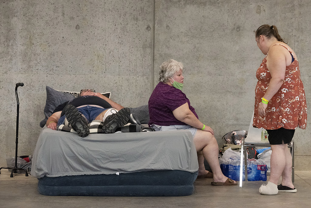
Bay St. Louis residents, from left, John Dixon, his wife, Sabrina Young, and Erika Crain talk at the Hancock County Evacuation Shelter in Kiln, Miss., on Monday in preparation for Hurricane Sally. “The people will be coming (to the shelter) but it will be too late. They’ll have the bare necessities,” Young says. “I did that with Katrina – the clothes on our backs and that was it. I don’t want to be in that situation again.” Barbara Gauntt/The Clarion-Ledger via AP
More than 2,000 evacuees from Hurricane Laura remain sheltered in Louisiana, most of them in New Orleans-area hotels, Gov. John Bel Edwards said.
The extraordinarily busy hurricane season — like the catastrophic wildfire season on the West Coast — has focused attention on the role of climate change.
Scientists say global warming is making the strongest of hurricanes, those with wind speeds of 110 mph or more, even stronger. Also, warmer air holds more moisture, making storms rainier, and rising seas from global warming make storm surges higher and more damaging.
In addition, scientists have been seeing tropical storms and hurricanes slow down once they hit the United States by about 17% since 1900, and that gives them the opportunity to unload more rain over one place, as 2017’s Hurricane Harvey did in Houston.
Copy the Story LinkSend questions/comments to the editors.

Success. Please wait for the page to reload. If the page does not reload within 5 seconds, please refresh the page.
Enter your email and password to access comments.
Hi, to comment on stories you must . This profile is in addition to your subscription and website login.
Already have a commenting profile? .
Invalid username/password.
Please check your email to confirm and complete your registration.
Only subscribers are eligible to post comments. Please subscribe or login first for digital access. Here’s why.
Use the form below to reset your password. When you've submitted your account email, we will send an email with a reset code.