
A new conservation project in Dallas Plantation in Franklin County will support a wide range of outdoor recreation activities and sustainable forestry while protecting older forests and sensitive habitats.
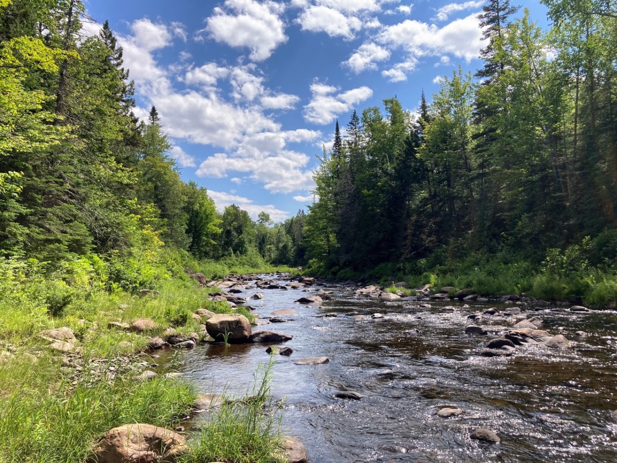
The South Branch Forest, an ecologically diverse, 3,586-acre parcel at the headwaters of the Kennebec River watershed, has been permanently protected, the Trust for Public Land announced in a news release Wednesday.
The property serves a conservation corridor in western Maine and Canada, a “critical ecological connector” linking over 200,000 acres of conserved lands, officials from the Maine Department of Agriculture Conservation and Forestry’s Bureau of Parks and Lands said.
The land will be managed to support multiple goals, the release said, including “guaranteeing public access for residents and visitors; enhancing experiences along the Northern Forest Canoe Trail; and supporting Maine Won’t Wait, the state’s climate action plan, through carbon sequestration, carbon storage and nurturing a mature forested environment.”
Betsy Cook, state director for the Trust for Public Lands, said the easement supports a wide breadth of recreation, including hiking, fishing, hunting, birding, snowmobiling, ATV use and biking on designated trails.
The collaborative effort, led by the trust, is in partnership with the Maine Department of Agriculture, Conservation and Forestry; U.S. Navy; and U.S. Forest Service.
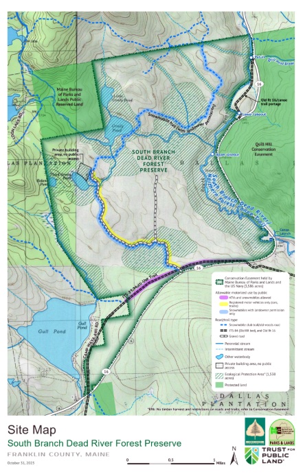
The conservation easement, located on the north side of Route 16, is co-held by the U.S. Navy and Maine Bureau of Parks and Lands. It was secured with contributions from the U.S. Forest Service Forest Legacy Program, U.S. Department of Defense Readiness and Environmental Protection Integration Program, and a private landowner whose generous contributions were essential to the project success and who will retain ownership and use of the land.
“I am so lucky to be a part of this team process of preserving and improving our forest land,” landowner Gene LeFevre said. “It always cheers me to see that a small band of well-intentioned citizens can move mountains and create something that improves the planet and sets an example of the good we can do when working with others.”
South Branch Forest, located minutes from Rangeley, is a region of undeveloped lakes, ponds and mature tree stands. There are healthy populations of moose, deer, waterfowl and brook trout. South Branch Forest includes 580 acres of wetlands, 80 acres of lakes and three great ponds of 10 acres or more.
Within the parcel are about 9 miles of streams, 4 miles of river and floodplain, and 5 miles of brook trout habitat deemed by Maine Department of Inland Fisheries and Wildlife as Species of Greatest Conservation Need, the Bureau of Public Lands said.
The forest also includes 388 acres of wading bird and waterfowl habitat, 820 acres of state-designated deer wintering yards, and three types of upland forest and seven types of wetlands, three of which are regionally rare. Some 374 acres contain habitats for Species of Special Concern.
Designated overland trails also will be open to motorized recreation, including a section of the popular Interconnected Trail System for snowmobiles and ATVs, and a gravel access road for motor vehicle access to a set of remote ponds.
The project permanently ensures public access to ITS-89.

A 7-mile stretch of the Northern Forest Canoe Trail on the South Branch of the Dead River, which connects Maine to New York by water, is also protected.
Through protecting the Dead River and maintaining public foot access across the property, the project supports a wide range of outdoor recreation opportunities, including hiking, hunting, birding and fishing.
Those permanent public access rights did not formally exist previously, according to Lynnette Batt, of the Trust for Public Lands.
Cook said the project fits squarely within the Trust for Public Land’s long-term strategy for western Maine.
“Western Maine is home to the state’s tallest mountains, pristine lakes and rivers, and hundreds of miles of trails — making it an ideal place for people to get outside,” Cook said. “Because of this, western Maine is an ideal location for Trust for Public Land to advance our goals of connecting everyone to the outdoors and creating a more climate resilient future for all.”
Cook said the trust has protected almost 200,000 acres of forestland in Maine over the past two decades, with one-third of those lands in western Maine. She added that over the past seven years, the organization has conserved 36,000 acres of connected land through six projects, including the South Branch project.
About half of South Branch Forest will be newly dedicated to preserving older forests, sensitive habitats and rare species; while the other half will continue to be sustainably harvested for timber and forest products.
About 1,500 acres are designated as an ecological protection area where no harvesting is allowed. Roughly 2,000 acres are designated as working forest under easement terms.
The combination of the two strategies — a model the bureau said aligns with its multiuse conservation approach — will maximize natural climate solutions of carbon sequestration and storage, enhance absorption of flood waters as a climate defense, strengthen habitat resiliency for a wide range of species, and provide economic benefits from sustainable timber harvesting,” the release said.
“The project is a unique opportunity to protect key outdoor recreation opportunities and important climate resilient ecosystems,” Cook said, adding that connections to the outdoors are a “need to have,” not just a “nice to have.”
“Protecting South Branch Forest provides a destination for local residents and visitors alike to get outside and explore the outdoors.”
Staff who worked on the project said this new conservation effort fills an important geographic gap as the South Branch Forest lies between two small public reserved land parcels managed by the bureau and is adjacent to the 7,000-acre Quill Hill conservation easement.
“The project’s connectivity furthers regional conservation goals by connecting large blocks of conserved lands totaling well over 200,000 acres, facilitating movement for lynx and other species,” BPL officials said. “The river corridor habitat and other values make the property especially valuable as plants and animals adapt and move in response to climate change.”
The connection extends toward the Bigelow Preserve and north into Quebec’s public crown lands by helping link the U.S. Navy’s Ursa Major property, the bureau’s Crocker Mountain and Loon Lake tracts, the New England Forestry Foundation’s Pingree easement, the bureau’s Davis C/U Reservation and Forest Society Maine easements.
Bureau officials said one remaining gap in conservation efforts is the 78,000-acre Magalloway project which would connect around 500,000 acres of conserved land in the region if completed. The project is being spearheaded by The Nature Conservancy, Forest Society of Maine, Rangeley Lakes Heritage Trust and Northeast Wilderness Trust.
We invite you to add your comments. We encourage a thoughtful exchange of ideas and information on this website. By joining the conversation, you are agreeing to our commenting policy and terms of use. More information is found on our FAQs. You can update your screen name on the member's center.
Comments are managed by our staff during regular business hours Monday through Friday as well as limited hours on Saturday and Sunday. Comments held for moderation outside of those hours may take longer to approve.
Join the Conversation
Please sign into your CentralMaine.com account to participate in conversations below. If you do not have an account, you can register or subscribe. Questions? Please see our FAQs.