
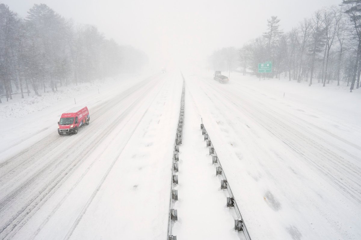
A blizzard is rolling into Maine on Monday, with several inches of snow expected and the entire coast facing possible whiteout conditions from falling and blowing snow.
A National Weather Service blizzard warning is in effect from 7 a.m. to 10 p.m. along the state’s whole coastline, from Eastport down to Kittery. Coastal flooding is possible in York County because of high waves.
A winter storm warning is in effect for a strip of Maine that includes Augusta, Bangor, Lewiston and Sanford, while a less-severe winter weather advisory covers inland areas from Norway and Rumford northeast to Houlton and Millinocket.
Meteorologists said Monday morning that the winter storm is expected to bring between 4 and 8 inches of snow to coastal Maine after rolling through the Northeast, while the interior parts of the state will see a limited impact. Earlier forecasts called for as much as 14 inches in some areas.
As the blizzard arrived, several school districts closed, and communities across the state issued parking bans ahead of the blustery, snowy conditions.
Forecasters warned that the conditions could make travel difficult and dangerous. Speed limits on the Maine Turnpike were temporarily lowered, flights out of the Portland International Jetport have been delayed or canceled, and bus and train lines reduced service.
Follow along for live updates on the storm and its effects on Maine.
———————————————————————————————————
3:13 p.m.: Waterville Opera House reschedules Lovett, Hiatt concert
Monday night’s performance of Lyle Lovett and John Hiatt at the Waterville Opera House has been rescheduled a week due to the weather. The Ed Harris Box Office, Ticonic Gallery and Studios and the Maine Film Center are all closed due to the weather.
— Jessica Lowell
11:15 a.m.: Local meetings cancelled, postponed in central Maine
Meetings scheduled for Monday evening have been postponed or cancelled across central Maine due to impending winter weather.
The Winthrop Town Council moved its meeting from 6:30 p.m. Monday to Thursday at the same time. The China Select Board rescheduled its regular meeting to Tuesday at 6 p.m. Winslow moved a Monday evening budget meeting to March 16.
A Waterville Board of Education meeting scheduled for Monday at 6 p.m. was cancelled. The board will hold its next regularly scheduled meeting March 9.
11:10 a.m. Augusta, Waterville to enforce parking bans
The cities of Augusta and Waterville will each enforce parking bans overnight.
Waterville Public Works will clear snow from downtown and The Concourse from midnight to 6 a.m. Tuesday. Overnight parking is available at the Head of Falls municipal lot.
Augusta’s parking ban goes into effect at noon Monday and ends noon Tuesday. No vehicles should be parked on any city street. Cars will be allowed in the downtown parking garage, the center Railroad Lot between Winthrop and Bridge streets and in the Mill Park lot.
11:03 a.m.: Lewiston Planning Board cancels meeting
The Lewiston Planning Board meeting scheduled for Monday, Feb. 23 has been cancelled because of the storm.
— Donna Perry
11:01 a.m.: Storm forces closures across central Maine
Administrative offices, city halls closed Monday:
- Augusta
- Belgrade
- Farmingdale
- Gardiner
- Hallowell
- Kennebec County
- Madison
- Monmouth
- Mount Vernon
- Randolph
- Richmond
- Vienna
- West Gardiner
- Winslow closing at noon
Schools closed Monday:
- Augusta School Department
- Richmond School Department
- Winthrop Public Schools
- Waterville Public Schools
- Winslow Public Schools
- RSU 2
- RSU 12
- RSU 18
- RSU 38
- MSAD 11
- MSAD 49
Libraries and community centers closed Monday:
- Gardiner Public Library
- Bailey Public Library
- Lithgow Public Library
- Madison Public Library
- Waterville Public Library
- Buker Community Center
- Richmond Senior Center
— Ethan Horton
10:50 a.m. National Weather Service says conditions are “rapidly deteriorating”
A new alert from the National Weather Service says heavy snow and stronger winds up to 40 mph are moving ashore along Maine’s coast, which will lead to low visibility while traveling.
Blizzard conditions are expected to continue and spread throughout the morning into the early afternoon, according to the agency.
“Prepare for rapidly deteriorating conditions and avoid travel if at all possible,” the alert read.
— Morgan Womack
10:05 a.m.: Lewiston announces parking ban, closes city buildings
A city-wide parking ban in Lewiston went into effect at 8 a.m. Monday and will continue to 5 a.m. on Tuesday.
All vehicles were to be removed from city streets before 8 a.m. to allow the Lewiston Public Works can clear the roads of snow, according to a post on city’s Facebook page.
The following Lewiston city buildings are also closed on Monday: City Hall, Public Library and Armory.
Officials remind residents that many city services are available online at www.lewistonmaine.gov/online.
— Donna Perry
9:30 a.m.: Auburn issues parking ban for Monday into Tuesday
The city of Auburn issued a parking ban starting Monday morning at 10 a.m. until Tuesday morning at 7 a.m. Residents can park their cars in city relief parking lots for free during the storm with a Winter Relief Parking Permit. Those permits can be obtained at the Auburn Police Department at Auburn City Hall.
— Kendra Caruso
9:25 a.m.: What does ‘blizzard conditions’ mean?
Meteorologists often use the term blizzard to describe heavy snowfalls and severe snow, but the National Weather Service also uses it to describe a combination of blowing snow and winds.
The agency’s official definition states that blizzard conditions occur when winds are higher than 35 mph, resulting in low visibility during travel. Blizzards often develop on the northwest side of an intense storm system. A difference in low pressure in a storm and high pressure outside of the storm creates a “tight pressure gradient,” which creates strong winds, according to the National Weather Service.
Even if it’s not snowing, this weather event can still cause whiteout conditions when snow on the ground is blown around. Strong winds can also cause power outages.
— Morgan Womack