

NEW ORLEANS — Tropical Storm Karen continued its slow trudge today toward the Gulf Coast, threatening to bring heavy wind and high rains despite losing some of its punch.
Officials from Louisiana to northwest Florida acknowledged that the storm was weakening and sent some emergency workers home, but urged residents to be cautious.
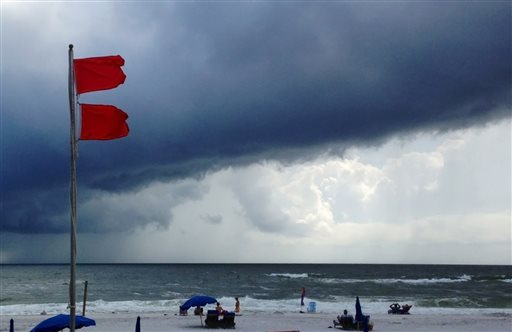
Additional Photos
“The storm’s weakened, and that’s good news, but we’re not out of the woods yet,” New Orleans Mayor Mitch Landrieu said at a news conference. He warned of likely high winds, street flooding and power outages.
The National Hurricane Center in Miami said forecasters had discontinued tropical storm watches across much of the Gulf Coast but that a portion of Louisiana remained under a tropical storm warning.
Karen stalled for several hours today but began moving slowly northward at about 2 mph (4 kph) by the late afternoon. It had maximum sustained winds of 40 mph (65 kph), making it a weak tropical storm.
Karen’s center was likely to come ashore either tonight or Sunday morning. It was expected to weaken further and lose tropical-storm status on Sunday.
Rick Knabb, the director of the National Hurricane Center in Miami, noted that “there is still the potential for some locally heavy rainfall and for some storm surge in coastal areas, but the magnitudes of those hazards greatly reduced. We still could see 1 to 3 feet of coastal flooding due to storm surge in some spots.”
In low-lying Plaquemines Parish, La., officials changed an evacuation order from mandatory to voluntary this afternoon. More than 80 evacuees from the area, at the state’s southeastern tip, had taken refuge at a public shelter, which would remain open today.
They gathered in an auditorium where they rested on cots, watched for weather updates on TV and chatted outside on the front steps.
“I don’t really know what to expect, but they told us to evacuate, so we got out,” said Dana Etienne, 27, of Phoenix, La., who was at the shelter with her three young children.
Ahead of the storm, squalls of rain hit workers sandbagging low sections of the flood-prone town of Lafitte, La., along Bayou Barataria.
“We have a high tide, but we only have another 15-17 hours to worry about, and I don’t think the tide will come up much more in that time,” Mayor Timothy Kerner said. “It looks like it might come up another foot or two, but I think we’re going to be OK.”
Coastal authorities closed flood gates along waterways that could be affected by tides driven by the storm. In New Orleans, the U.S. Army Corps of Engineers continued closing barriers designed to keep surge out of the Inner Harbor Navigation Canal — scene of catastrophic flooding in 2005 when flood walls failed during Hurricane Katrina.
Col. Richard Hansen of the corps said more gates along various canals could be closed, and warned boaters not to get caught on the wrong side of those gates “If there is a gate in the system, it may not be open when you decide to come back in,” Hansen said. “So it’s time to pull your boats out of the water and quit fishing.”
At the Port of New Orleans, port officials working with the Coast Guard said they were optimistic that vessel traffic at the mouth of the Mississippi River, halted since Friday morning, would resume Sunday. The port remained busy, officials said in a news release, with some of the nine ships at dock there still working cargo. Two Carnival cruise ships that had to delay weekend arrivals were expected Monday.
Dan Hahn, emergency operations planner for Santa Rosa County in the Florida Panhandle said Karen appeared to be a “nonevent” for the region.
The county had activated its Emergency Operations Center for the weekend, but decided to close it after getting the latest update on the storm’s path. Hahn said he and other officials were relieved the storm wasn’t more developed. But Hahn still urged residents to pay attention to weather updates and to be prepared for any emergency.
“Complacency is always a concern, but we aren’t seeing that,” he said, adding that most Panhandle residents take tropical weather seriously because of the large storms that have struck the region in the past.
Mississippi Emergency Management Agency spokesman Brett Carr said the Mississippi National Guard was demobilized today after coastal county officials said they “didn’t see the need to keep them around.”
Karen was poised to be only the second named storm to make landfall in the U.S. during an unusually quiet hurricane season. The first was Tropical Storm Andrea, which hit Florida, in June. The season runs from June 1 through Nov. 30.
As the storm churned the Gulf, some people along the coast couldn’t resist the draw of beaches.
Ray and Lynn Walls of Shepherdsville, Ky., had a sunny beach to themselves today on the western tip of Dauphin Island, Ala. Waves pounded the seawall protecting nearby homes, and a locked gate blocked the entrance to a public beach that was closed because of Karen.
The trip had been planned for four people, but only two showed up, Ray Walls said. “The rest of them got a little scared of the storm.”
In Biloxi, Miss., families played on the beach, joggers trotted along the waterfront and a steady stream of cars passed on the main beach front road.
Karen’s weakening meant possible disappointment for Cheryl Greer, who drove through the night from Nicholasville, Ky., on a weekend adventure to Mississippi to visit her daughter and experience her first tropical storm.
“I’m looking forward to it. It would be my first one,” she said. “I’m going to come to the beach and video it.”
Associated Press reporters Stacey Plaisance in Braithwaite, La.; Melissa Nelson in Pensacola, Fla.; Tony Winton in Miami; Holbrook Mohr in Biloxi, Miss.; and Jay Reeves in Dauphin Island, Ala., contributed to this story.
Copy the Story LinkSend questions/comments to the editors.

Success. Please wait for the page to reload. If the page does not reload within 5 seconds, please refresh the page.
Enter your email and password to access comments.
Hi, to comment on stories you must . This profile is in addition to your subscription and website login.
Already have a commenting profile? .
Invalid username/password.
Please check your email to confirm and complete your registration.
Only subscribers are eligible to post comments. Please subscribe or login first for digital access. Here’s why.
Use the form below to reset your password. When you've submitted your account email, we will send an email with a reset code.