

If it seems like we haven’t had a day without clouds, wind, or cool temperatures lately, your perception is spot on. Wednesday qualified as a nice day, but a sea breeze kept the coastline rather chilly. The good news: this afternoon is finally going to feature warmer air. The bad news: It’s not going to last and we have more wind.
We have some major weather changes coming over the next five days with warm, slightly muggy, and showery weather followed by cold — and even the likelihood of some snow. The warm and cold weather so close together will not only affect our collective mental state, it could damage some flower buds.
MARCH WEATHER MADNESS TAKES A BREAK
On Wednesday, many inland areas reached the lower and even mid-50s. It was warmest back through the Sanford, Bridgton areas, but nice all the way to Waterville. The average high is in the mid-40s to upper 40s this time of year. High pressure, which generally brings nice weather to the area, will remain in control this afternoon, but since it will move east, winds will once again kick up, especially along the coast.
Highs will reach the 60s today and there will be lots of sunshine. If I didn’t think the wind would be so gusty, I’d say it would be an ideal day. This warm air will certainly help the buds to open further, and you’ll notice trees taking on a green or reddish hue depending on type.
Tomorrow, a strong cold front to our west will force muggy and moist air up the Eastern Seaboard. The storm system to which this front is connected is the same one that brought snow to the Rockies and rain to the Midwest. This storm will move into Canada and give us a period of showers Friday.
HERE COMES THE COLD
Saturday is still seasonable, but a true arctic front will be pushing south and east late in the day and usher in a period of winter temperatures and possible snow showers. The cold arrives Saturday night and any rain showers might change to snow by early Sunday. Sunday is going to feel like winter again, with highs at least 10 degrees below average.
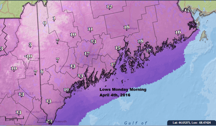
The problem with the cold on the heels of such mild air is that some of the apple, peach, and other fruit tree blossoms can open enough so the cold will injure them. If this occurs, there wouldn’t be any fruit this fall on those trees. I am most concerned about Monday and Tuesday mornings next week.
APPLE ORCHARD ISSUES
Predicting flower damage is very difficult and can vary from one orchard to the next. However, it’s a real possibility next week. So while it’s likely none of us is going to be happy with another week of wild temperature extremes, it can have a lasting impact long after it’s over.
You can follow more of my forecasts and gardening tips on Twitter @growingwisdom.
Send questions/comments to the editors.

Comments are no longer available on this story