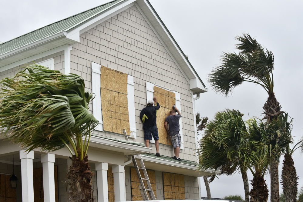
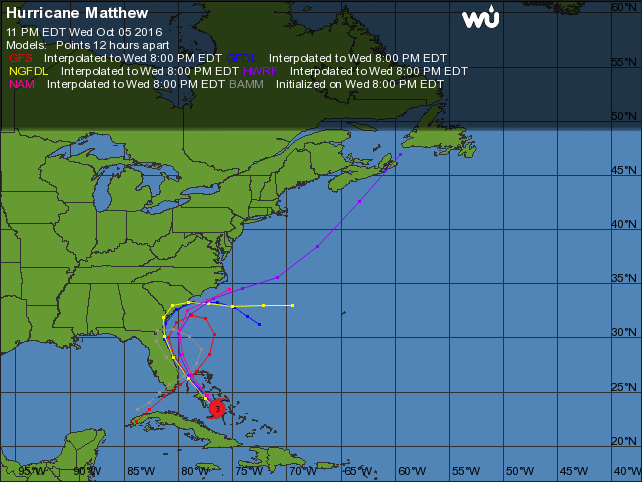
MELBOURNE BEACH, Fla. — Forecasters say Hurricane Matthew has gained new muscle over the Bahamas and they are also expanding the hurricane warning area farther up the Southeast Atlantic seacoast from Florida into Georgia.
The U.S. National Hurricane Center in Miami says Matthew’s top sustained winds have risen from 115 mph to 125 mph in just a few hours early Thursday as the storm continues to batter the central Bahamas.
The center added in its 5 a.m. Thursday update that Matthew should gain further in intensity over the next day or so and is forecast to become a Category 4 storm as it approaches Florida’s Atlantic coast.
In a Category 4 hurricane, winds range from 131 to 155 mph and can cause catastrophic damage to property, humans, and animals. Cat 4 hurricanes often include long-term power outages and water shortages lasting for weeks.
Matthew’s center is now about 255 miles southeast of West Palm Beach, Florida, and moving northwest at 12 mph over the Bahamas.
Nearly 2 million people along the coasts of Florida, Georgia and the Carolinas were urged to evacuate their homes, as the dangerous and life-threatening storm was expected to be very near Florida’s Atlantic coast by Thursday evening.
The storm was forecast to scrape much of the Florida coast, and any slight deviation could mean landfall or a turn farther out to sea. Either way, it was expected to be close enough to wreak havoc along the southern part of the East Coast, and many people weren’t taking any chances.
In Melbourne Beach, near the Kennedy Space Center, Carlos and April Medina moved their paddle board and kayak inside the garage and took pictures off the walls of their home about 500 feet from the coast. They moved the pool furniture inside, turned off the water, disconnected all electrical appliances and emptied their refrigerator.
They then hopped in a truck filled with legal documents, jewelry and a decorative carved shell that had once belonged to April Medina’s great-grandfather and headed west to Orlando, where they planned to ride out the storm with their daughter’s family.
“The way we see it, if it maintains its current path, we get tropical storm-strength winds. If it makes a little shift to the left, it could be a Category 2 or 3 and I don’t want to be anywhere near it,” Carlos Medina said. “We are just being a little safe, a little bit more cautious.”
About 20 miles away in the town of Cape Canaveral, John Long said Hurricane Matthew is just hype as his neighbors in his RV park packed up and evacuated inland. Even though his 32-foot RV is just feet from the Banana River and a half-mile from the beach, he had no plans to leave.
Long, who owns a bike shop and has lived along the Space Coast for 30 years, said he has a generator and enough food and water for himself and his cats to last a week.
“There’s always tremendous buildup and then it’s no stronger than an afternoon thunderstorm,” he said. “I’m not anticipating that much damage.”
In Fort Lauderdale, about 200 miles south, six employees at a seven-bedroom Mediterranean-style mansion packed up for an evacuation fearing any storm surge could flood the property. The homeowners planned to move to another home they own in Palm Beach that’s further from the water. Two Lamborghinis and a Ferrari had been put in the garage, but employee Mae White wasn’t sure what they would do with a Rolls Royce, Mustang and other cars still parked in the driveway.
“This storm surge. It’s scary,” White said. “You’re on the water, you’ve got to go.”
The last Category 3 storm or higher to hit the United States was Wilma in October 2005. It made landfall with 120 mph (190 kph) winds in southwest Florida, killing five people as it pushed through the Everglades and into the Fort Lauderdale and Palm Beach area. It caused an estimated $21 billion in damage and left thousands of residents without power for more than a week. It concluded a two-year span when a record eight hurricanes hit the state.
As of 11 p.m. EDT Wednesday, Matthew was centered about 325 miles southeast of West Palm Beach and moving northwest, according to the National Hurricane Center . Hurricane-force winds extended 45 miles from the center.
“When a hurricane is forecast to take a track roughly parallel to a coastline, as Matthew is forecast to do from Florida through South Carolina, it becomes very difficult to specify impacts at any one location,” said National Hurricane Center forecaster Lixion Avila.
Florida can expect as much as 10 inches of rain in some isolated areas.
In South Carolina, Gov. Nikki Haley reversed the lanes of Interstate 26 so that all lanes of traffic were headed west and out of Charleston. It was the first time the lanes had been reversed. Plans to reverse the lanes were made after hours-long traffic jams during Hurricane Floyd in 1999.
The governor planned to call for more evacuations Thursday, which would bring the total to about 500,000 people in the state. Florida urged or ordered about 1.5 million to leave the coast, said Jackie Schutz, spokeswoman for Gov. Rick Scott. Georgia had around 50,000 people who were told to go.
At Folly Beach, South Carolina, southwest of Charleston, Gaby Trompeter loaded her car at her beachfront home preparing to evacuate to Augusta, Georgia.
Trompeter, a 50-year-old goldsmith who designs and makes jewelry, remembers Hurricane Hugo when she stayed in Savannah, Georgia, in 1989.
A year ago when what has been described as a 1,000-year flood inundated South Carolina there was so much water on the road near her house she couldn’t get out for three days.
“If it brings a lot of rain, more than the storm last year, why would I want to stay?” she said.
President Obama visited the Federal Emergency Management Agency’s headquarters Wednesday to be briefed on preparations. FEMA has deployed personnel to emergency operation centers in Florida, Georgia, South Carolina and North Carolina. It’s also positioning commodities and other supplies at Fort Bragg in North Carolina and in Albany, Georgia.
On the Georgia coast, 92-year-old Lou Arcangeli saw two of his adult children come to his home on Tybee Island to help prepare and evacuate if necessary.
“It’s serious,” said Arcangeli, who has lived in the Savannah area since 1979, when Hurricane David became the last hurricane to make landfall on Georgia’s 100-mile coast. “I’m going to keep an eye on it and not wait until the last minute. As far as I’m concerned, what’s going to happen is going to happen.”
Farmers in Matthew’s path scrambled to protect their crops. In South Carolina, Jeremy Cannon was harvesting his soybeans a week early after waiting too long before last year’s record rainstorm. He watched his soybeans and cotton crops slowly drown as 20 inches of rain fell, costing him $800,000.
“I don’t want to lose a single soybean this year if I don’t have to,” Cannon said. “The Lord says pray without ceasing. And that’s what I’ve been doing — in the fields, near the barn — just praying all the time. I don’t want to find out what I’ll have to do if I get wiped out for another year.”
Send questions/comments to the editors.


Success. Please wait for the page to reload. If the page does not reload within 5 seconds, please refresh the page.
Enter your email and password to access comments.
Hi, to comment on stories you must . This profile is in addition to your subscription and website login.
Already have a commenting profile? .
Invalid username/password.
Please check your email to confirm and complete your registration.
Only subscribers are eligible to post comments. Please subscribe or login first for digital access. Here’s why.
Use the form below to reset your password. When you've submitted your account email, we will send an email with a reset code.