
SOUTH PORTLAND — It’s the busiest stretch of the busiest street in the city, causing commuter headaches for years and leading some to question whether a plan to consolidate two aging middle schools on one site might worsen traffic congestion.
The road is Broadway, a winding, mostly two-lane, cross-city artery that’s nearly unavoidable if you want to get from one side of South Portland to the other without driving far afield.
The worst section is a 1,000-foot, four-lane bottleneck between Evans and Lincoln streets that carries about 24,240 vehicles daily, according to the Maine Department of Transportation. It’s the locus of several road and trail projects that are meant to reduce traffic congestion on Broadway in the coming years.
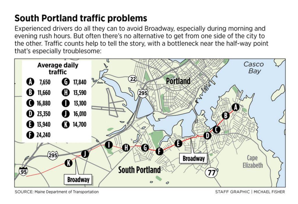
Experienced drivers do all they can to avoid the area, especially during morning and evening rush hours. The only street in the city that’s busier is the start of Western Avenue, near Westbrook Street, where traffic to and from the Maine Mall area draws more than 26,000 vehicles daily.
“You do everything you can to get away from Broadway,” said Carlton Grover, a truck driver who works for a contracting firm located off Broadway. He drives the road every day. Come quitting time, Grover and his co-workers sometimes hang out and shoot the breeze to delay the inevitable.
“Because we know if we leave, we’re just going to sit in traffic,” he said.
Erin Lord lives in South Portland and works at the Amato’s restaurant at Broadway and Evans Street. She sees how traffic backs up in both directions. If she wants to go to the mall area, just a few miles down Broadway, she’ll drive an extra mile or two through Portland to Interstate 295 so she doesn’t have to deal with frustrating congestion.
“I’ll go over the Casco Bay Bridge to avoid traffic on Broadway,” Lord said.
MIDDLE SCHOOL PROJECT
Broadway’s traffic troubles cropped up most recently over a proposal to build a new, state-funded middle school on the site of the existing Memorial Middle School, which is just off Broadway on Wescott Road, on the west side of the city. The $50 million project also would replace Mahoney Middle School, which is at Broadway and Ocean Street, on the east side of the city.
In a June straw vote, city residents overwhelmingly approved the concept of building a consolidated middle school on the Memorial site for grades 5 through 8, incorporating fifth-graders from the city’s crowded elementary schools. The project faces a second straw vote on the building and site design in October, followed by a citywide referendum on the overall project as early as June 2019.
While many residents have praised the consolidation plan as thoughtful, practical and fiscally responsible, several people who participated in the 151-49 straw vote complained that it would eliminate a middle school on the east side and exacerbate traffic problems on Broadway.
Some worried that many parents who live on the east side would drive their children across the city to the Memorial site – something many already do at both middle schools – further clogging Broadway traffic. When it was suggested that students could ride school buses as a reasonable, eco-friendly alternative, some parents said a half-hour bus ride for some students would be untenable.
School officials plan to do what they can to limit the impact of a consolidated school on Broadway traffic and student travel time. They’ll use special software to plot the most efficient routes and consider staggered school start times for grades 5 and 6, and grades 7 and 8.
The project would include slight changes to Broadway, Wescott Road and Westbrook Street to improve traffic near the school campus, which includes Skillin Elementary School.
“We’re concerned with getting students, staff and community members to and from the site as safely and efficiently as possible,” said Superintendent Ken Kunin.
LOW SCHOOL BUS RIDERSHIP
The school district also hopes to encourage more students to ride school buses, which could take hundreds of cars off the road, Kunin said.
According to an informal classroom survey conducted in June, 52 percent of Mahoney students were driven to school by a parent or other adult, while 27 percent walked, 13 percent rode a bike, skateboard or scooter and 8 percent rode a school bus. Mahoney has only one school bus because so few students choose to ride.
At Memorial, 46 percent of students surveyed rode a school bus, 32 percent were driven to school by a parent or other adult, 18 percent walked and 4 percent rode a bike, skateboard or scooter. Memorial has five school buses, in part because many students live in the West End neighborhood on the other side of I-295, including residents of the Redbank Village apartment complex.
“We’d certainly like to see more use of school buses,” Kunin said. “Having one vehicle carrying 50 to 60 students instead of having 50 or 60 cars on the road seems to make perfect sense for practical and environmental reasons.”
Kunin recalled that the city in the past has considered building a connector road from Highland Avenue, past the Wainwright Recreation Complex, to Rumery Road. However, that project never got off the ground because it would be costly to build and require environmental permits to disturb a large swath of wetlands.
Kunin also noted planned pedestrian improvements to the city’s roads and recreational trails that he hopes will allow more students to walk or bike more safely to school, although state funding for off-site work related to the middle school project would be limited.
The Bike-Pedestrian Committee has recommended construction of an off-road trail along Westbrook Street, from the West End neighborhood, beneath the I-295 overpass, across Broadway to Wescott Road. That project has yet to be approved.
The state Department of Transportation is expected to start a $1.37 million road and trail project in 2020 that will connect the multi-use path from the Veterans’ Memorial Bridge to the city’s Greenbelt Walkway, which runs from Bug Light Park on the east side of the city to the Wainwright complex on the west side.
The new path will run along Billy Vachon Drive, Lincoln Street and Broadway, connecting to the existing walkway where it crosses Broadway at Evans Street. The city will fund $342,000 of the project, including road and drainage work along Lincoln Street.
EXIT 4 AND OTHER PROJECTS
Also in the Lincoln Street area, the state is scheduled to build a southbound on-ramp at Exit 4 of I-295, said Tex Haeuser, city planning director. The exit currently consists of a northbound on-ramp and a southbound off-ramp.
The $2.4 million project is expected to siphon off a significant amount of Broadway traffic that’s currently heading to the mall area and the Maine Turnpike/Interstate 95, including fuel tank trucks from the city’s waterfront terminals, according to a state proposal.
It also will reduce traffic volume through the Cash Corner intersection of Broadway and Main Street/Route 1, which is chronically congested and considered a high crash location, with an average of 11 vehicle crashes per year.
Adding a southbound on-ramp at Exit 4 will remove 1,855 vehicles daily from Broadway to Westbrook Street and 1,056 vehicles daily from Main Street to the Maine Turnpike Connector, according to a traffic engineer’s projections.
The city’s share of the Exit 4 project will be about $240,000. Construction is expected to start in 2019. Adding a northbound off-ramp isn’t currently feasible because of railroad tracks and fuel storage tanks near the exit, but state transportation officials have indicated that it could be considered in the future.
Also in 2019, the state is set to install coordinated traffic signals on Broadway at Lincoln and Evans streets that are projected to reduce vehicle congestion by 15 percent to 44 percent, depending on the location and time, Haeuser said. The $100,000 project will add to the city’s system of coordinated signals near the Maine Mall and Mill Creek shopping areas.
In addition, the state is set to upgrade the coordinated traffic signals at Cash Corner and install crosswalks to improve traffic and pedestrian safety at that Broadway-Main Street intersection. Similar improvements are planned at Main Street and Rumery Road, at a combined cost of $72,000.
Also next year, the state is on track to lengthen the right-turn lane from the Casco Bay Bridge onto Broadway, so that turning traffic will be able to exit more efficiently. Currently, queuing traffic in the bridge’s eastbound lane blocks the right-turn lane during peak travel hours.
The $500,000 project will maintain the existing bike path and include improved traffic signals, pedestrian crossings and Greenbelt Pathway connections throughout the Mill Creek area.
With each improvement project, city and state officials anticipate that traveling on Broadway will become less frustrating. Maybe even enjoyable.
“We are constrained to one arterial roadway to get from one side of the city to the other,” Haeuser said. “In general, our transportation goals are to provide safe and relatively congestion-free options for people driving vehicles and real alternatives through biking, walking and public transit.”
Comments are no longer available on this story