There are few ways to confuse somebody from away more than directing them to head “Down East.” Not because the broad path of Route 1 is difficult to follow, but because of the inherent oxymoron: coming into the state near the Kittery tolls, the eastern coast travels up – and often to the right – but definitely not down. The origin can be traced the state’s nautical history because you travel “downwind” to go east – but now, at the end of tourist season, I can’t help but think it stays in fashion partly so locals can enjoy the confused looks on drivers from out of state.
Confusion aside, I feel confident saying that the terminology has never done anything to deter somebody from actually traveling Down East because some of the most scenic spots in the state can be found along the northeastern coast. If you travel all the way Down East, beyond historic Fort Knox, picturesque Stonington and renowned Acadia National Park, you’ll find one of the most distinctive and photogenic destinations of all: West Quoddy Head Light, the easternmost point in the United States.
Quoddy Head State Park is very simple to get to; simply go east until you can’t go east anymore. Follow Route 1 to the Washington County town of Whiting, then take Route 189 (also known as County Road) for 8.5 miles, to South Lubec Road. In 4 miles, you’ll reach the entrance of the state park, where there are two parking areas: bear right for the Inland and Coastal hiking trails; or left for the lighthouse, visitor center and accessible Coast Guard Trail.
The distinctive red-striped lighthouse, which has graced countless postcards and a USPS stamp, stands next to a large stone monument that marks it as “the easternmost point in the U.S.A.” The seasonally operated visitor center is filled with interesting historical photos, artifacts and information from the light station’s 200-plus year history (the first light station was built here in 1808 by order of Thomas Jefferson). Tours of the tower are offered on Saturdays in the summer months.
Here at the mouth of the Bay of Fundy, tides are spectacular and the weather is dramatic; the fog can roll in so thick and so often that in 1827, Congress declared the keeper should receive an extra $60 annually “in addition to his present salary,” for the additional time he had to spend ringing the fog bell. In clear weather, however, you’ll look over Quoddy Channel to beautiful views of Grand Manan Island.

The milelong Coast Guard Trail is accessible and rewards the hiker with incredible views. Photo by Jake Christie
From the lighthouse parking lot, the short 1-mile Coast Guard Trail is worth the modest effort, offering striking views of Campobello Island and Lubec across the Quoddy Narrows. Traversing the trail clockwise, the first 0.5-mile stretch to an observation deck is accessible to motorized wheelchairs (and with assistance for non-motorized chairs). Beyond the observation deck, the trail becomes narrower and hillier, following the high cliffs on the eastern end of the peninsula as it leads back to the lighthouse. Numerous openings and spurs look over the Narrows, where distinctive landmarks on Campobello like its southern Liberty Point can be seen.
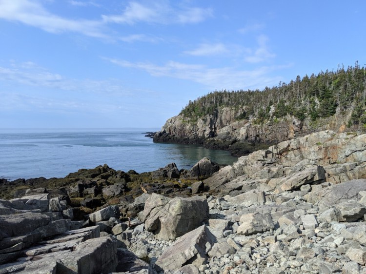
From the inland parking lot, the Coastal Trail takes you on a more strenuous 4-mile loop, deep into the 541 acres that make up the state park. Beginning near Sail Rock (a dangerous sail-shaped rock that snared many boats in the fog-enveloped waters), the trail passes through spruce trees clinging to the rugged terrain, spotted with pink twinflowers in summertime. At 0.3 miles, the trail hugs the edge of Gulliver’s Hole – a high, narrow cove that surges with spectacular waves, bringing to mind the cliffs of Monhegan or more southerly stretches of the Bold Coast.
Continuing along the cliff heights, the trail passes the aptly named High Ledge and Green Point. More and more scoured dead spruce mix with the living trees here, where water and wind blasts the coast; low-growing vegetation and bright orange lichen thrive, however, painting the trail and bluffs with bright colors.
At 1.2 miles, the Coastal Trail passes a little “pocket beach,” where the bluffs have crumbled into pebbles, cobbles and small boulders. Finally, near the 2-mile point, a bench looks over raised Carrying Place Cove Bog – a National Natural Landmark, one of only six such fully featured peatlands in the U.S. – and the 1,200-foot sandy beach at Carrying Place Cove. This is where a narrow strip of land connects Quoddy Head to the mainland – for now. As the sights along the trail attest (powerful waves, deep coves, crumbling cliffs), erosion is an incredibly powerful force. In centuries to come, as the cove and bog slowly expand, Quoddy Head could someday become Quoddy Island.
From Carrying Place Cove, you can retrace your steps back on the Coastal Trail, or follow the wooded inland Thompson Trail back to the trailhead. As you approach the trail intersection near Gulliver’s Hole, the 0.2-mile out-and-back Bog Trail offers an opportunity to follow a raised boardwalk through another bog, with interpretive signs describing how the plants here survive and thrive.
Quoddy Head State Park is open to the public during daylight hours year-round, but the visitor center is open only from Memorial Day weekend through mid-October (10 a.m. to 4 p.m. daily). If you visit after mid-October, consider using the time you would have spent in the visitor center on the charming Main Street of nearby Lubec; experiencing history just over the border at Campobello Roosevelt International Park; or traversing the stunning cliffs of Cutler’s Bold Coast Preserve. There’s a lot to explore in this corner of Maine, even in the offseason.
Jake Christie is a freelance writer living in Portland. Along with his brother, Josh, he writes about great Maine destinations for outdoors enthusiasts. Jake can be reached at:
jakechristie@gmail.com
Comments are not available on this story.
Send questions/comments to the editors.


