

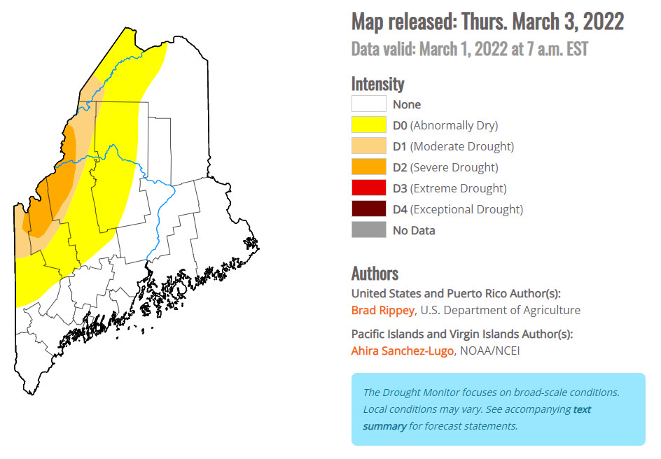
Nearly all of Oxford, Franklin and Piscataquis counties and northwest Aroostook County are in drought conditions U.S. Drought Monitor
After two years of drought conditions in western Maine, the U.S. Geological Survey is seeing some of the lowest groundwater levels on record, said Nicholas Stasulis, Maine River Flow Advisory Commission co-chairman and data section chief, U.S. Geological Survey.
Groundwater monitoring sites in northern Franklin and Somerset counties are “going on a year of being on the very low end of what we see is normal for those sites, if not a record low,” Stasulis said.
Records for these sites go back to the 1980s.
The U.S. Geological Survey is closely monitoring an area roughly stretching from Jackman to Eustis, down through northern and central Oxford County where groundwater levels have been especially low, he said.
A chart used to gauge how far from normal groundwater levels are. U.S. Geologic Survey
The groundwater level at a monitoring site in Eustis was “low,” Oxford was “much below normal,” Weld was “below normal,” and near the outlet of Lower Richardson Lake in northern Oxford County was “high” in February, according to data from Stasulis.
In 2021, 21 wells were reported to be dry across Maine during a statewide drought. Four of these wells were in Oxford County, two in Franklin County, and one in Somerset County.
“What we need in order to kind of relieve some of these drought conditions, we need a good snowpack, and we need rain that doesn’t all fall at once,” Stasulis said.
Data from the National Weather Service shows that snowpack across Maine has been normal to low this winter. Rangeley, which is in severe drought conditions, has received 30 fewer inches of snow than average. Augusta, Portland and Jackman have gotten roughly a foot of snow less than normal.
While there aren’t many people who live in the most severely impacted area of the state, the drought conditions could significantly affect the water levels of streams, rivers and lakes, which are fed from western and northwestern Maine, Stasulis said. This includes the watersheds of the Androscoggin and Kennebec rivers.
“Without significant recharge to bring them back up to normal or above normal levels, then we would expect that they would maintain that same (low water) condition” this summer, Stasulis said.
Low water levels could reduce hydropower generation and hurt recreation. However, storage dams in the watershed help to regulate flows and mitigate droughts.
“The stream flows, maybe haven’t looked as bad, because those rivers are being regulated to keep water levels where they need to be,” he said. “So while water levels are below normal, they’re not record low, critically low, (unlike some) groundwater levels. Obviously there’s no capability for somebody to hold back water and release water (into the ground) like we have with streams.”
Even a wet spring won’t necessarily mean water levels will return to normal this summer. The last two droughts have come quickly, Stasulis said, calling them “flash droughts.”
“If we have another one of these very prolonged periods of no (precipitation) like we had last summer and the summer before, we could still end up being in that same condition,” he said. “But if we have another hot, dry summer, we’re just going to keep seeing the same conditions, over and over again. We’re just not getting that like frequent rainfall in the spring and summer that we have seen in the past.”
In their annual meeting last week, the Maine River Flow Advisory Commission determined that flood risk for the state is normal, however conditions could change quickly if the state receives a big rainstorm while snow remains on the ground.
There’s no way to tell what precipitation may be like in the coming months.
Send questions/comments to the editors.

Comments are no longer available on this story