


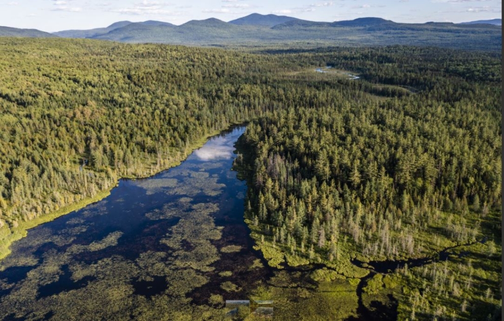
An aerial view of Upper Hathan Bog in Coburn Gore Township, part of the Forest Society of Maine’s conservation of 8,175 acres in northern Franklin County. Jerry Monkman/ECOPhotograpy.
COBURN GORE TOWNSHIP — An undeveloped 8,175 acres of forest owned by the same family since 1970 is now conserved forever and permanently protected on both sides of state Route 27.
It is “home to an important piece to a portion of the American Revolution War history — the Benedict Arnold Trail,” according to a news release from the Forest Society of Maine.
The organization announced Monday that it holds conservation easements on the property. Of the 8,175 acres, 7,075 acres is working forests, which will continue as such, and 1,100 acres is designated as an ecological reserve, Karin Tilberg, president and chief executive officer of the society said Monday.
The entire forested landscape supports “sustainable forest management, important wildlife habitat, recreational opportunities and historical features.”
The society, established in 1984, raised $4.2 million in public and private funds to get the easement.
The Coburn Gore Forest Conservation Project, which was previously an unprotected forest in a conservation corridor, is now permanently conserved from development, Tilberg said.
The property is on both sides of state Route 27, which runs through northern Franklin County to the border crossing at Coburn Gore into Canada.
“If this family didn’t have the vision of conservation, this area would most likely be developed,” she said. “It is just wonderful this family has this vision and wants to keep it forest.”
Blue flag iris are seen on the shore of a small pond in Coburn Gore Township. It is part of the Forest Society of Maine’s 8,175-acre conservation in northern Franklin County. Jerry Monkman/EcoPhotography photo
The project lands have been owned since 1970 by the same family and managed by the same logging family since then.
The Coburn Gore Forest connects conserved land in Maine to public lands in Quebec, both public recreation and wildlife management areas and Nature Conservancy Canada lands. Together the properties create a network totaling nearly 200,000 acres, according to the release.
“This project builds on the growing awareness that Maine’s forests are globally significant, containing landscape-scale, contiguous, undeveloped tracts of forests,” Tilberg said in the release. “It also honors the tradition of stewardship by family forest owners.”
The ecological reserve is a sensitive area with some very significant bogs, some older forests, an area deer to winter in and important natural forests, she said. It now has an extra layer of protection.
The Coburn Gore property contains the headwaters that flow to the Chain of Ponds, Dead River, and ultimately the Kennebec River.
These cold-water ponds and streams, surrounded by undeveloped forestland, are essential to maintaining the high-quality brook trout resource the region is known for, according to the release. Ponds in the conservation area include Crosby Pond and Arnold Pond.
The many wetlands on the property provide habitat for a variety of plant and animal species, including bald eagles, osprey, several species of hawks and woodpeckers, migrating songbirds, bats, and several rare plants. Two ponds within the project area boast nesting pairs of loons every summer.
The property is really a significant area for water quality and wildlife, Tilberg said.
These lands are highly rated for their resiliency to climate change. Large landscapes with elevation gradients, such as this forest, allow for species to adapt to changes in climactic conditions, and this project will continue supporting wildlife and plant biodiversity moving forward, the release states.
A travel route established by the original inhabitants of the area and later used by European settlers traverses the project land, Tilberg said.
“This is a big deal project, as this area is one of the still relatively pristine areas of the Arnold March that is important to have conserved,” Arthur Spiess, senior archaeologist for Maine Historic Preservation Commission, said in the release. “By preventing future development, this conservation easement conserves Indigenous routes and history in perpetuity.”
Many supporters made project’s success possible. Vital information about the project lands was provided by the society partners: Arnold Historical Society, Maine Natural Areas Program, The Nature Conservancy, and U.S. Fish and Wildlife Service.
Essential funding for the conservation of the property included leadership grants from four individuals, Bafflin Foundation, Davis Conservation Foundation, Jane’s Trust, Lookout Foundation, Maine Community Foundation Arboretum Fund, the North American Wetlands Conservation Act, and the U.S. Fish and Wildlife Service Loon Mitigation Fund. The society also recognized “the critical support provided by (eight) additional foundations and organizations and more than 100 other people.”
Copy the Story LinkSend questions/comments to the editors.

Success. Please wait for the page to reload. If the page does not reload within 5 seconds, please refresh the page.
Enter your email and password to access comments.
Hi, to comment on stories you must . This profile is in addition to your subscription and website login.
Already have a commenting profile? .
Invalid username/password.
Please check your email to confirm and complete your registration.
Only subscribers are eligible to post comments. Please subscribe or login first for digital access. Here’s why.
Use the form below to reset your password. When you've submitted your account email, we will send an email with a reset code.