


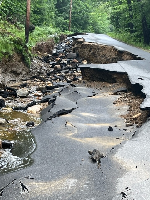
JAY — Preliminary estimates of damage to local roads and sewer lines from the June 29 torrential rainstorm is nearly $4 million, Town Manager Shiloh LaFreniere said.
A Jay public works crew works June 30 to get residents access to their homes on Soules Hill Road. The road was undermined in the June 29 rainstorm that dumped 5 to 6 inches in two hours. Town of Jay photo
Some sections of roads are closed but others have been repaired.
The damage to a section of Whistle Stop Trail, a multiuse rail-trail owned by the state, is estimated now at $500,000, Brian Bronson, supervisor of the state’s Off Road Recreational Vehicle Program, said.
John Johnson, the town’s director of Public Works, and LaFreniere were still working Friday on the preliminary damage estimates which will be submitted to the state for consideration for a federal disaster declaration.
The Maine Department of Transportation is still calculating preliminary damage estimates for roads in Jay and other places.
If a federal declaration is not received, the town and state will be responsible to pay for the repairs of its roads.
The deadline to submit estimates was Friday.
Meeting at the Jay Town Office on Thursday to discuss preliminary estimates were LaFreniere and other representatives of Jay, and representatives of the Maine Department of Transportation, Maine Department of Conservation’s Bureau of Parks and Lands and Franklin County Emergency Management Agency.
Jay Sewer Superintendent Mark Holt said Friday that there was roughly 1,300 feet of sewer main washed out in a line along state Route 4 on the south side of Jay Hill and a preliminary estimate of $1.1 million to fix it. The rail-trail sewer transmission line and access damage is estimated now at $69,000 to repair, he said.
Jay’s sewer line runs beside the Whistle Stop Trail from North Jay village to the Hannaford Plaza in Jay several years ago. It is treated at the treatment plant in Livermore Falls.
The Whistle Stop Trail is closed from basically U.S. Route 2/state Route 4 near Steve’s Family Market in Dryden village in Wilton to the Jay Plaza in Jay, Bronson said.
There’s $500,000 in damage along that section of the trail.
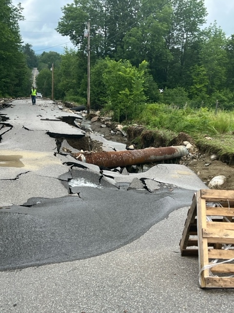
Davenport Hill Road in Jay washed out June 29 in a rainstorm that dumped 5 to 6 inches in two hours. A town crew has made is accessible to residents who live along it. Town of Jay photo
“There is a huge washout, I mean, 50 feet deep,” Bronson said.
To get a Presidential Federal Disaster Declaration takes time for approval and money before they can even talk about repairs, he said.
“I don’t know that there’s any way to route around it,” Bronson said. “There’s nothing that we’ve been able to find. So far. So the trail is closed for the foreseeable future. It could very well be next year before it gets repaired,” Bronson said.
The estimates are for restoring the roads and the trail to the way it was before the flooding, LaFreniere said.
They are trying to find out if they do upgrades, such as adding a larger culvert to handle more water, if it would be covered under a disaster declaration, she said.
The preliminary estimates would be used to see if the the town and state meet the thresholds to qualify for a federal assistance.
Gov. Janet Mills submitted a request to President Joe Biden for a Declaration of Disaster for the April 30 and May 1 flooding. The Franklin, Kennebec, Knox, Lincoln, Oxford, Sagadahoc, Somerset and Waldo counties exceeded county damage thresholds and collectively the state’s threshold. He approved the declaration Friday.
Franklin County’s threshold is $130,785 and the validated damage was $318,932 for that storm. The state’s threshold is $2.4 million and the damages combined were nearly $4 million.
Franklin County preliminary estimates will include Jay, which had major damage, and preliminary estimate of damages recorded by Chesterville, Farmington and Wilton, which were minor, to help Jay, Amanda Simoneau, director of Franklin County Emergency Management Agency, said Thursday.
There are other counties collecting preliminary damage estimates, Vanessa Corson, spokeswoman for the Maine Emergency Management Agency said.
The rainfall June 29 was between 5 and 6 inches in a two-hour period, Simoneau said. Her aunt who lives on state Route 133 registered 9 inches in her rain gauge.
LaFreniere posted an update on the road status on Thursday.
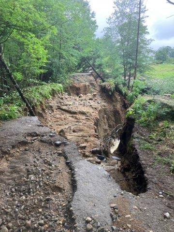
A section of the Whistle Stop Trail in Jay is shown June 30, a day after a rainstorm dumped 5 to 6 inches in two hours. The trail, which runs from Jay to West Farmington, is closed from U.S. Route 2/state Route 4 to Jay Plaza in Jay. Brian Bronson, supervisor of Maine’s Off Road Recreational Vehicle Program, said, “There are several washouts, including one ‘huge’ one that is 50 feet deep.” Brian Bronson photo
The state has repaired state routes 4, 140 and 156 so they could be reopened. There will be more repairs in the future.
State Route 133 north of the Hyde Road through Beans Corner at the intersection of Route 156 is still closed. The DOT has estimated it will be closed for about a month, LaFreniere said.
“Residents living on Macomber Hill Road may use (state) Route 133 to Lomie Rivers Road to access their homes,” she wrote. “There are still complete washouts on the Route 4 end of Macomber Hill Road and on Woodman Hill road so there is no access through these roads.”
A contractor has nearly completed repairs on Look Brook Circle.
There are also complete washouts on Davenport Hill Road and Hutchinson Road. The Public Works Department has made repairs to Davenport Hill Road so it is accessible to those living on the road but there is a complete washout around 330 Davenport Hill Road so residents have to access the lower street numbers from state Route 140 and higher street numbers from Morse Hill Road in North Jay. There is no through traffic.
The washout on the north end of the East Jay Road has been made passable, LaFreniere wrote. It is not fully restored but vehicles can access it with caution. The Soules Hill Road is still closed to traffic.
The Canton Mountain Road is being repaired, she wrote. If people do not live on the road, she asks that they don’t drive on it.
The Davis Road has been restored to provide access to residents’ homes but state Route 133 at the end of Davis Road is closed. Davis Road is not a through way and one cannot access state Route 133 from it.
There is still a complete washout on the Chesterville end of the East Jay Road so traffic cannot get through there. Access to the far end of the East Jay Road and the upper section of Soules Hill Road is through Chesterville.
The Public Works crew was working Friday to get people access to their homes on Soules Hill Road. It will not be for through traffic but for residents only, LaFreniere said.
“Some of the areas that are completely washed out will require permitting from the (Maine Department of Environmental Protection) and, or the Army Corp of Engineers as well as engineering work to address culvert upgrades as part of the (Federal Emergency Management Agency) process,” she wrote.
These include Begin Road, Macomber Hill Road, Hutchinson Road and East Jay Road.
LaFreniere thanked residents for their patience.
She said there are still several other smaller roads that have limited access, as well as many roads that still have washouts on the edge and shoulder areas. She asked people to not attempt to go around the barricades, warning signs or cones blocking off areas.
Copy the Story LinkSend questions/comments to the editors.

Success. Please wait for the page to reload. If the page does not reload within 5 seconds, please refresh the page.
Enter your email and password to access comments.
Hi, to comment on stories you must . This profile is in addition to your subscription and website login.
Already have a commenting profile? .
Invalid username/password.
Please check your email to confirm and complete your registration.
Only subscribers are eligible to post comments. Please subscribe or login first for digital access. Here’s why.
Use the form below to reset your password. When you've submitted your account email, we will send an email with a reset code.