

More snow is on the way to Maine, with an incoming storm expected to drop between 2 and 8 inches on much of the state Tuesday night through Wednesday afternoon.
The National Weather Service has placed southern, central and Down East Maine and all of New Hampshire under a winter weather advisory that’s in effect from 7 p.m. Tuesday to 4 p.m. Wednesday.
The fast-moving “clipper” system is expected to bring snow from Alberta to the Gulf of Maine, said Justin Arnott, a meteorologist at the weather service’s office in Gray.
“The system will move out of Canada and through the Great Lakes early Tuesday morning,” Arnott said Monday afternoon. “It will spread into our area by Tuesday evening and move offshore Wednesday.”
The storm is forecast to arrive in Maine just after the Tuesday night rush hour, but drivers are likely in for a messy Wednesday morning commute.
“Just be prepared for slick roads,” Arnott said.
MAINE’S SNOW FORECAST
Coastal communities from Wiscasset to Belfast stand a chance of seeing up to 8 inches of snow from this system, according to the weather service.
The weather service is projecting the majority of southern, central and western Maine will receive 4 to 6 inches, in a broad area stretching from Sanford north into Penobscot County and from Down East westward into northern New Hampshire. That swath includes Augusta, Bangor, Bar Harbor, Fryeburg, Lewiston, Machias, Rumford and Skowhegan.
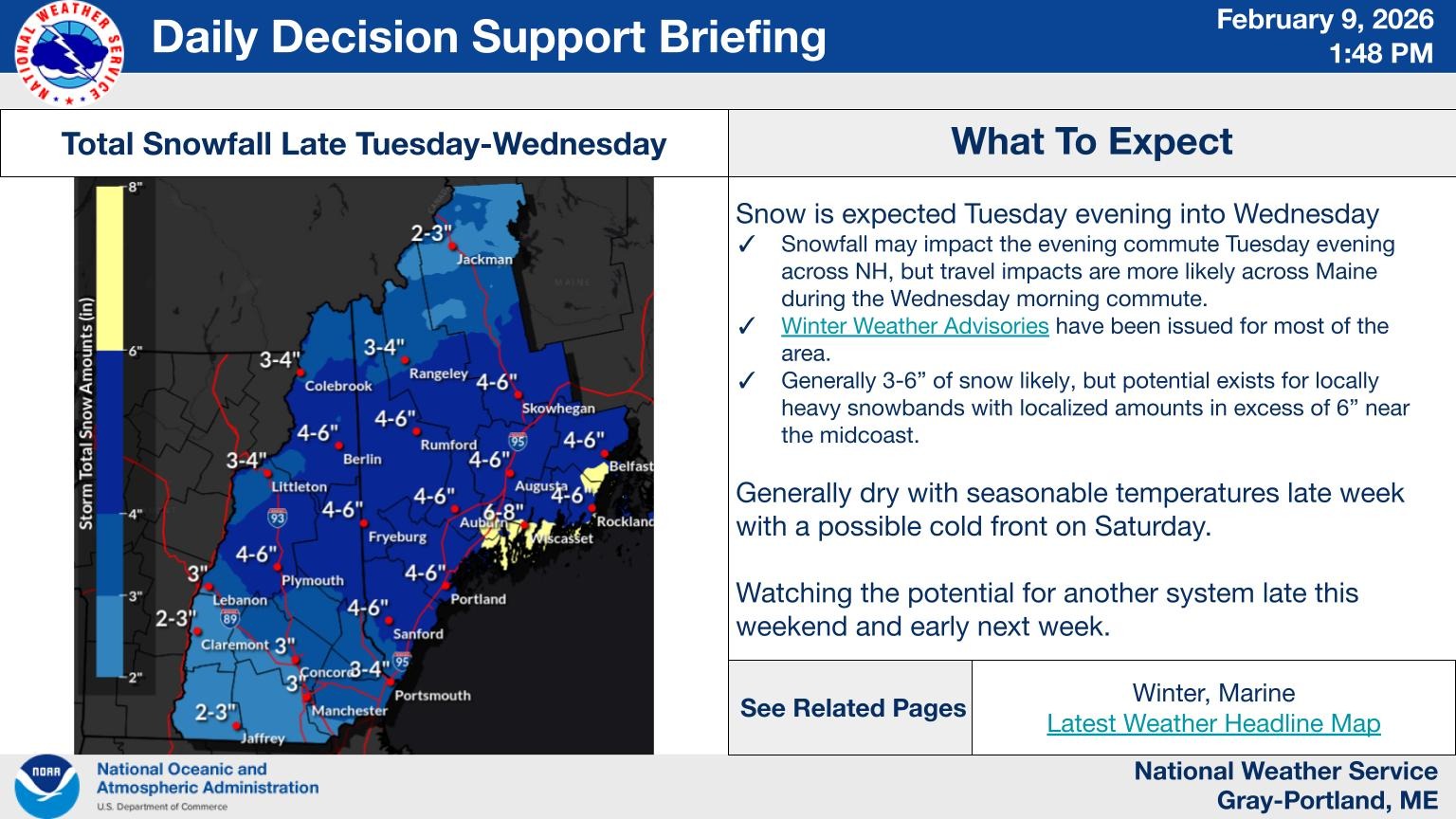
Communities from Rangeley to Dover-Foxcroft and Calais mark the northern edge of that band and should expect 3 to 4 inches, according to the weather service. A small band farther north could see 2 to 3 inches.
“It looks like the heaviest (snowfall) will be earlier on,” Arnott said, likely between 9 p.m. Tuesday and the early-morning hours of Wednesday. “By daybreak, it’ll likely be lightening up.”
Northern Somerset, Piscataquis and Penobscot counties could see between 1 to 2 inches, while northern Aroostook County is expected to see less than an inch, according to the weather service’s office in Caribou.
While most of Maine is on pace to see snowflakes sometime Tuesday night, the precipitation isn’t expected to begin until early Wednesday morning in the northern and easternmost portions of Maine.
Warming up (relatively)
Those not looking forward to the snow may find a silver lining in Tuesday and Wednesday’s expected temperatures after a frigid arctic front brought subzero wind chills to Maine over the weekend.
“The clouds and snow will actually keep temperatures a little bit warmer than they have been,” Arnott said.
Overnight Tuesday, Arnott projected temperatures in southern Maine to fall to the high teens, while the high Wednesday could land in the low to mid-30s.
“In fact, that will be the trend for the rest of the week,” Arnott said.
While that’s par for the course this time of year, Arnott noted that some Mainers may consider those temperatures “mild” — relatively speaking — in the wake of the cold snap.
We invite you to add your comments. We encourage a thoughtful exchange of ideas and information on this website. By joining the conversation, you are agreeing to our commenting policy and terms of use. More information is found on our FAQs. You can update your screen name on the member's center.
Comments are managed by our staff during regular business hours Monday through Friday as well as limited hours on Saturday and Sunday. Comments held for moderation outside of those hours may take longer to approve.
Join the Conversation
Please sign into your CentralMaine.com account to participate in conversations below. If you do not have an account, you can register or subscribe. Questions? Please see our FAQs.