
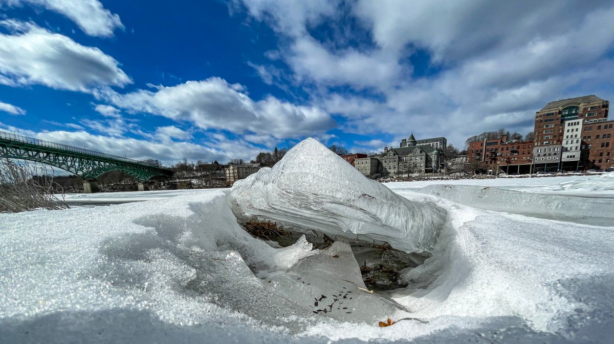
While the risk of flooding from snowmelt and rain adding to Maine’s rivers is low this year, the potential for flooding caused by ice jams is up, due to very thick ice on rivers such as the Kennebec and Androscoggin.
The Maine River Flow Advisory Commission met Thursday to review ice conditions, stream flow and snowpack levels, the spring weather outlook, drought conditions, and flood risks across the state.
Even if an upcoming warm spell melts a significant amount of the snowpack, places that trap and store water, like groundwater, wetlands, and other areas, have plenty of capacity to take it on without causing flooding.
However, the ice still on most Maine rivers presents a substantially higher risk than normal of ice jams forming; those jams can block off river flow and cause rapid and damaging flooding.
James Sinko, a senior hydrologist with the National Weather Service Office in Caribou, said a lot of thick ice has built up during multiple cold snaps. If the weather and river conditions take a turn and cause the ice to break up into large chunks, they could jam and block the river flow, causing flooding above the jam that could rise over riverbanks and wreak havoc.
Sinko said there is a less than 10% chance the state’s main rivers get enough flooding to reach the point where anyone would need to take action. However, Sarah Jamison, also a senior hydrologist with the weather service, warned that projection does not account for any ice jam flooding.
Authorities who measured the ice on the Kennebec River in Richmond and Gardiner on Thursday said it was between 8 and 14 inches thick.

Jamison said warm weather, with temperatures reaching into the 60s, and some rain coming within the next week or so will cause snow to melt and ice to degrade. But it does not appear that would be sufficient to break up the thick river ice, yet, she said, although she warned conditions vary and are unpredictable.
While in recent years the ice on the Kennebec River has melted or broken up and flowed out to sea on its own, this year the U.S. Coast Guard anticipates being called to to break up the ice and lessen the chances of ice jams.
Lt. Amanda Barnett said ice breakers were recently deployed on the Penobscot River, and she anticipates they’ll be called to break ice on the Kennebec, likely in mid- or late March, although that will be up to officials keeping an eye on the Kennebec.
Barnett said the Coast Guard’s 65-foot harbor tugs can break ice up to about 12 inches thick. Because of repairs, the Coast Guard may be down to only one tug when it comes time to do the Kennebec, she said, although she hoped a second vessel could be repaired in time to join in on that task.
Ryan Gordon, director of the Maine Geological Survey, said statewide snowfall was slightly below normal this winter, in both snow depth and water content.
River levels, too, are generally low across the state.

Claire Briggs, hydropower specialist for the state Department of Environmental Protection, said the Androscoggin River in Auburn is below historic averages for this time of year, at 32% full, compared to 50% full in March of last year.
Nicholas Stasulis, of the USGS, a co-chairman of the commission, said while water levels are below level now, a single major storm — especially one featuring rain on top of snow, or a very large rain event — could rapidly put water levels above normal and increase the risk of flooding. But he said no such storms are currently on the horizon.
Even with the snow that has fallen across Maine this winter, groundwater is so low it’s setting records and will require a substantial amount of rain to fill the deficit, and the state remains in a drought.
Stasulis said some sites are at record lows of groundwater, and they’ve seen little to no recharge of water since May.
Jamison said the state needs precipitation in the mountains and headwaters to make a difference in restocking groundwater levels. She’s hopeful warmer weather will bring snowmelt that will allow for some recharge of the groundwater supply, especially in southern Maine. She said the coming warm weather will likely melt the remaining snow in the Portland area, but it won’t likely take away all the snow in the rest of the state.
The Maine River Flow Advisory Commission was formed after spring floods in 1983 to improve the exchange of hydrologic information, review data and provide information to emergency agencies and the public.
Its members include officials from Maine Emergency Management Agency, U.S. Geological Survey, river basin managers, National Weather Service, U.S. Coast Guard, and Maine Floodplain Management Program.
Editor’s note: This story was updated to correct the names of Lt. Amanda Barnett and James Sinko.
We invite you to add your comments. We encourage a thoughtful exchange of ideas and information on this website. By joining the conversation, you are agreeing to our commenting policy and terms of use. More information is found on our FAQs. You can update your screen name on the member's center.
Comments are managed by our staff during regular business hours Monday through Friday as well as limited hours on Saturday and Sunday. Comments held for moderation outside of those hours may take longer to approve.
Join the Conversation
Please sign into your CentralMaine.com account to participate in conversations below. If you do not have an account, you can register or subscribe. Questions? Please see our FAQs.