
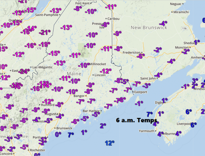
It’s a cold morning across the area with winds continuing, but not damaging. Wind chills are going to be running below zero much of the day, although the coldest air is of course the first few hours after sunrise. Later today, highs will barely reach the single numbers over the mountains to lower teens at the coastline in southern York County. This will be the coldest day since Valentine ’s Day this year.
The cold air is an important piece of the forecasting puzzle this weekend. As warmer air moves north overnight and tomorrow, it will ride up and over the dense cold air at the surface. This will create what we call lift and produce clouds and snow. Since the cold air is heavy, it’s tough to move and leads to snow lasting for several hours tomorrow morning. A winter weather advisory for the snow and mixed precipitation has been posted for the area throughout Saturday.
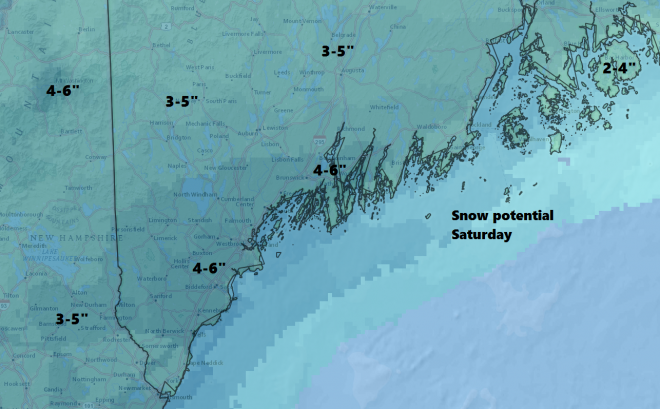
Eventually the warm air will win out and change the snow to sleet, freezing rain or just some plain rain, but most of the precipitation will have already fallen, especially away from the coastline. This means a plowable storm with up to 5 or even 6 inches of snow in those areas with the maximum totals. The map below gives an idea of how much snow you should end up with. I will be updating these maps on Twitter @growingwisdom throughout the storm.
Saturday night will bring some freezing drizzle or perhaps a few showers, but you should be able to get out and around if you have plans.
Sunday will be a mild day with highs in the upper 40s over southern Maine to lower 40s even in the mountains. If you can handle the wet conditions, skiing should be quite good. Look for some melting. The cold air rushes back in Sunday evening with a quick freeze of any leftover slush, so be sure to remove it or it will be there for a while.
Cold Arctic air returns on Monday, but not as cold as this morning.
If you’re going skiing.
Ski country will see 3-5 inches of snow Saturday with some rain on Sunday morning. Plan on conditions changing throughout the weekend – cold highs in the 20s on Saturday and much milder in the lower 40s Sunday.
If you’re playing any field games or winter golf…
This isn’t the weekend to be out on the fields. You can get some exercise shoveling. Just take it slow if the snow becomes heavier.
If you’re raking and gardening…
Don’t brush off plants with snow, the cold makes them brittle and easy to break. Wait until it becomes warmer.
If you’re hiking or walking or running…
Saturday will be snowy in the morning and damp in the afternoon. I pick Sunday as the best day to run because it will be mild, but watch out for rain showers and heavier downpours.
If you’re running errands and holiday shopping…
Look for snowy roads on Saturday, especially in the morning. I would factor in extra time to get around. This isn’t a storm you can’t drive in, however.
I will be updating the forecast on Twitter @growingwisdom throughout the weekend.
Comments are no longer available on this story