
Holiday weekends are never a time when you want to see bad weather. You especially don’t want to see it multiple times during a holiday weekend, yet that’s exactly what we have coming up for the long weekend of Christmas celebrations.
The bottom line is, Mainers will contend with almost every type of precipitation that’s possible over the next few days, with the exception of hail, which generally occurs during thunderstorms. That said, this isn’t likely to be a blockbuster event, unless the freezing rain portion really takes off. However, the prolonged nature of the wintry weather on Christmas weekend makes this a higher impact event than usual. It’s all about timing and the precipitation type.
Here’s a day-by-day breakdown of what to expect:
FRIDAY
Snow continues through the day today. The snow will fall into the evening and may mix with sleet over southern areas. We’ll all see enough snow to bring back winter driving and a slow commute.
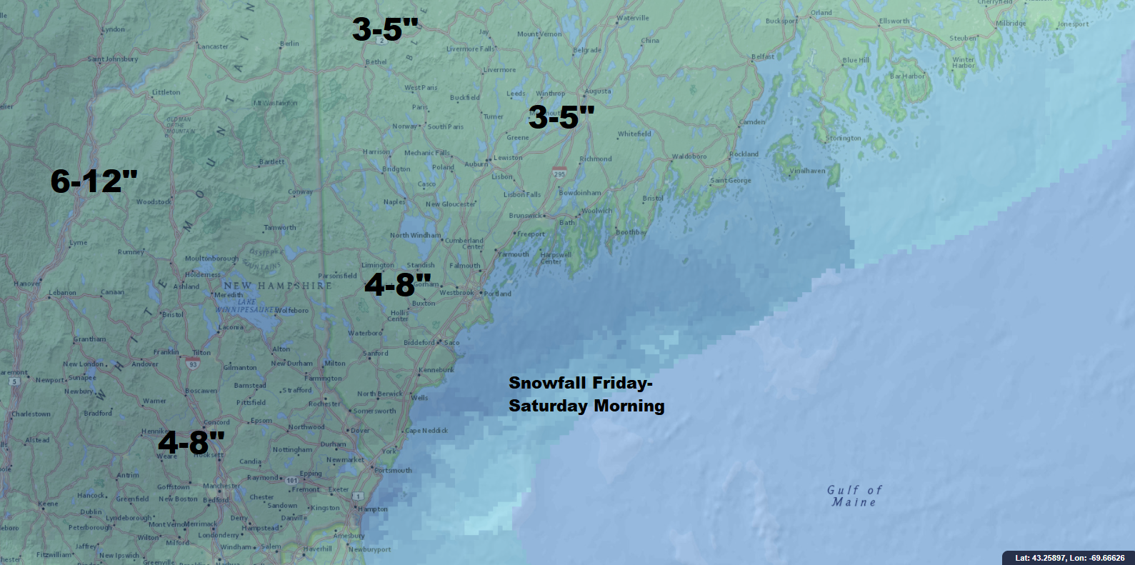
A plowable storm is likely Friday into Friday night across Maine. (Dave Epstein)
FRIDAY NIGHT
Warmer air is going to start to move northward at high levels of the atmosphere. Snow may begin to change to freezing rain late at night along the coast and over extreme southern Maine. This will create a situation in which, as the precipitation falls out of the clouds as snow, it melts into liquid. When it comes down to the ground – which will be below 32 degrees – it will freeze, causing a glaze. Freezing rain is the most hazardous type of precipitation. The lack of friction on the roads often causes numerous accidents and the weight of the ice on trees and power lines, if it builds up enough, can cause power outages.
Freezing rain events are very difficult to predict because the difference of a degree or two in temperature makes a tremendous change to what’s happening on the ground. If we look back at something called analogs, which are ways to look at these similar situations in the past, we see that the analogs for this particular weather set up give nearly a 90 percent chance of inland areas of southern Maine seeing at least three hours of freezing rain early Saturday.
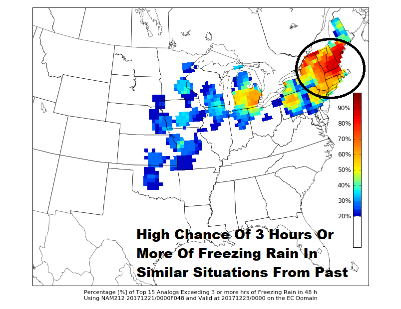
Freezing rain is most likely over southern Maine Friday night and early Saturday.
SATURDAY
Precipitation will trend from snow to freezing rain to rain as it finally ends. There may be a period of just plain rain along the immediate coast if enough mild air moves north, but this isn’t a sure bet. There won’t be any rain in the mountains so skiing remains great heading into the holiday weekend.
SUNDAY
On Christmas Eve day we’ll get a break with some sunshine and temperatures in the mid-30s to right around 40 degrees.
MONDAY
Christmas will dawn with snow likely falling across much of the region. This particular storm is still three days away and the guidance we use to predict it is not definitive. It looks like snow will break out after midnight Christmas Eve and last through at least the first part of the morning on Christmas Day. I expect several more inches of snow from this storm. There is virtually no doubt it’s a white Christmas for all of us this year!
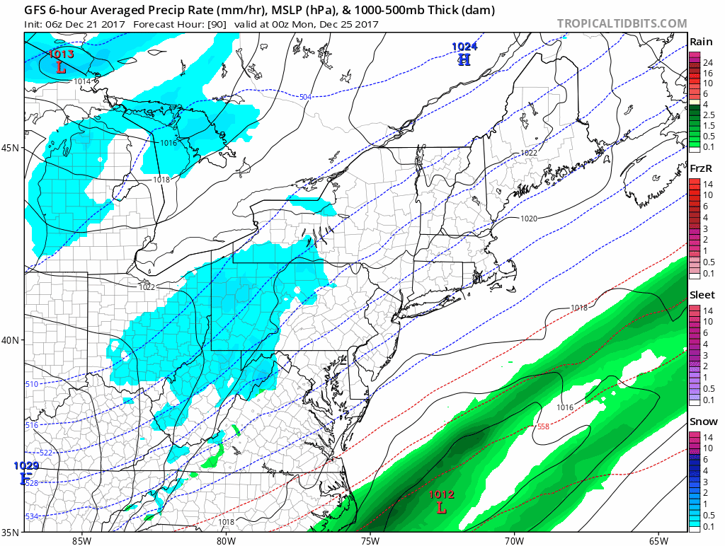
A snow event may bring more white for Christmas. Tropical Tidbits.
This is a very complicated forecast, about as complicated as it gets around here, and the type of weather you’ll experience during the Friday to Monday time frame will depend on exactly where you live. Definitely listen to latest forecast before you head out.
Comments are no longer available on this story