HANOVER, N.H. — To see it today, Mason’s Four Corners is simply the crisscrossing of walking trails on the Trescott Water Supply Lands, off Trescott Road in Hanover.
But two centuries ago, it was the bustling intersection of Knapp and Wolfeboro roads, a stone’s throw from the district’s one-room schoolhouse and community center, three reservoirs and 10 thriving farms, including the nine-generation Mason family farm, for which the intersection was named.
All that’s left of the neighborhood lies within a handful of crumbling cellar holes, which nature has largely reclaimed over the years.

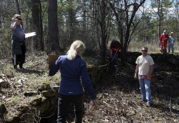
Jane Henry of Hanover, N.H., sketches the layout of the cellar hole at the former Stone family farm in Hanover on Saturday. The four corners of the foundation are aligned with the cardinal directions to maximize exposure to the sun during the winter. James M. Patterson/The Valley News via AP
But that was enough for the 20 or so “citizen-archeologists” who showed up for an exploratory hike Saturday morning, organized by the Hanover Conservancy and led by its executive director, Adair Mulligan. Over the 21/2-hour outing, the hikers uncovered long-lost relics of the dismantled neighborhood and helped cobble together a better understanding of the history of the land.
“It seemed like an enjoyable outdoor activity for us,” said Jason Chen of Hanover. His 8-year-old daughter, Amy, was writing down her observations in a notebook. “A hike, but also a history of the area.”
Some hikers already knew a thing or two about the subject, like Dick Baughman, who brought along a book of local history to supplement Mulligan’s spiel.
While the group paused at Mason’s Four Corners, he opened to a page that showed the ice house and gas-powered sawmill from the town’s poor farm, which was established to the west of Knapp Road as a place where orphans, aging widows, people with disabilities and other “unfortunates” could live and work.
“They kept people busy,” Mulligan said, adding that the poor farm’s residents also “earned their keep” by planting and harvesting potatoes.
Wolfeboro Road was New Hampshire’s first cross-country highway, built in the 1770s for colonial Gov. John Wentworth when he wanted to attend commencement at Dartmouth College. A quarter-mile down the road, hikers found a cellar hole from the farmhouse of Charles Stone.
The carriage road was familiar territory for Baughman, who once hiked a stretch of Wolfeboro Road from Hanover Center, all the way to the far side of Moose Mountain.
Not much is known about the Stone farm, except that it dates back to at least 1855, and that Stone traded the watershed property for one on Route 10 in Hanover. According to Mulligan, he moved there with all his cows in a single day.
“Can you imagine the spectacle of it?” she said. But, colorful though this anecdote may be, “a lot more research needs to be done.”
The group took what’s called an “inventory” of the Stone cellar hole, recording its features and dimensions. They made some discoveries that helped piece together a picture of what this overgrown patch of land might have looked like.
There were clusters of bricks on opposite sides of the hole, which Mulligan interpreted as the remains of two chimneys, rather than the usual one.
There were daylilies sprouting out of the south side of the cellar hole, suggesting that someone planted them in the front garden of what was probably the south-facing house. The apple tree growing out of the cellar hole was non-native, meaning that apples must have been stored there – Mulligan said this wasn’t surprising, considering “they needed apples like crazy” in those days, not only for pies but also to ferment into cider and vinegar, to preserve food through the long winter.
Hanover resident Bill Boyle noticed a round depression in the earth that he thought might have been Stone’s well. Other group members stumbled upon what Mulligan believed to be the foundation of the Stone family’s long-dismantled barn.
“Hey!” called Linde McNamara of Hanover from a grassy knoll on the north side of the house. “We found the outhouse!”
The explorers noted a few other relics from the past: a pile of tin cans; a sap bucket; a rusted milk jug; a fragment of stoneware that was salt-glazed, probably for storing liquid; and a carriage wheel that was embedded into a tree. Tom Kronkite guessed that the wheel must have been lying flat on the ground when the tree grew up from underneath it, “and eventually the two became one,” he said.
“Nature and history, merging yet again,” Mulligan said.
On the walk back to the Trescott Road trailhead, Jay Hull of Hanover expressed his pleasant surprise at the day’s findings.
“I didn’t expect to be measuring and digging,” he said. “It’s work in one sense, play in another.”
Send questions/comments to the editors.


Success. Please wait for the page to reload. If the page does not reload within 5 seconds, please refresh the page.
Enter your email and password to access comments.
Hi, to comment on stories you must . This profile is in addition to your subscription and website login.
Already have a commenting profile? .
Invalid username/password.
Please check your email to confirm and complete your registration.
Only subscribers are eligible to post comments. Please subscribe or login first for digital access. Here’s why.
Use the form below to reset your password. When you've submitted your account email, we will send an email with a reset code.