
A summer fling results in cold feelings this weekend. No, really, the forecast on Saturday is wicked warm, while ice and snow are on the table for Sunday.
SATURDAY
Saturday gets quite toasty, considering it’s January in New England. So warm, in fact, that some records could be tied or broken. This is most likely to happen in southern Maine, though central Maine could get in on the action, too.
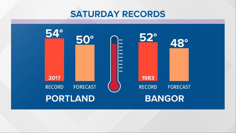
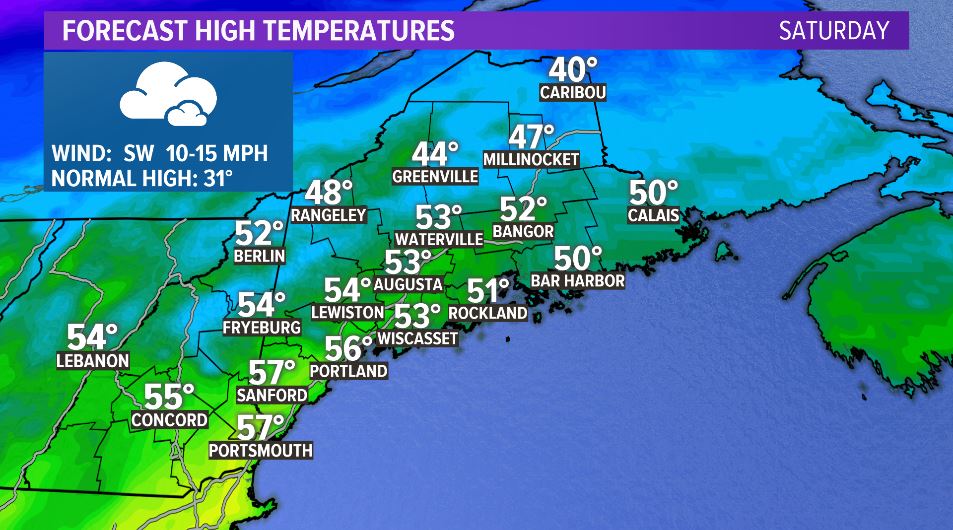
The warmth will be widespread. Temperatures surge even into northern Maine. For reference, normal highs are in the upper 20s and low 30s. We will likely be 20 to 30 degrees above average Saturday afternoon and evening.
So, if we’ll be so warm Saturday, how come Sunday looks so messy? Let me explain.
SUNDAY
Arctic high pressure sets up to the north. Cold, dense air flows around this high and the wind switches to be out of the north and northeast early Sunday morning.
As low pressure develops over the Great Lakes, the warmer, less-dense air flows in from the southwest. The result is wicked cold air bottled up at the surface and warmer air riding on top of it – the perfect ingredients to get ice.

As a scientist, I think the best way to describe what’s happening is to look at a cross section of our atmosphere and how it affects what falls from the sky.
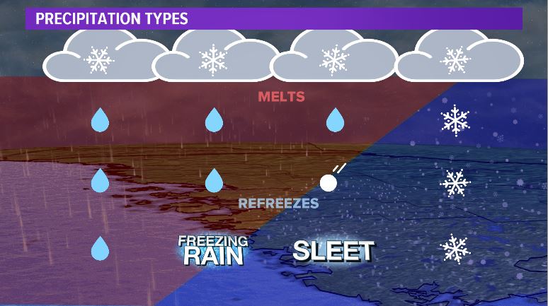
In the image above, red represents warm and blue represents cold. The bottom of the image is the ground and the top of the image is where the clouds are.
As cold air undercuts the warmer air, snowflakes fall from the clouds and melt through the warm layer. If the cold layer is deep enough, it will refreeze and fall as sleet.
However, if it’s a shallow layer of very cold air, it does not have enough time to refreeze and will fall as rain. Once it runs into the ground and any objects that are below freezing, it will freeze on contact. Sleet has less of an impact than this freezing rain.
Ice starts on Sunday morning in northern Maine with a quick transition to snow.
Along the coastline, it will be mostly rain.
Central Maine is the “bulls-eye” for the ice to start in the morning and stick around into the afternoon. As such, this is where the highest ice accretion totals are likely. The line of highest impacts will lie from Fryeburg to Lewiston to Augusta to Bangor.
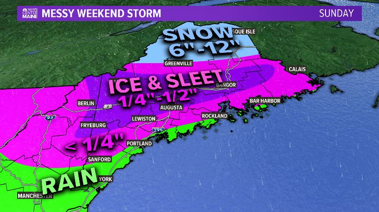
There are still some possible changes to this map as we get closer to the weekend. Overall, it looks pretty messy on Sunday. Some power outages are possible.
I do not think this will be an infamous ice event, such as the 1998 Ice Storm. Because it’s a relatively quick event and the wind gusts will not be too high, we should avoid a catastrophic storm.
A quieter day is on the way Monday. There’s a chance for some warmer days next week, too, but none that will challenge Saturday.
Stay tuned for some minor forecast tweaks over the next couple days. You can also get more forecast info by following me on Twitter or Facebook.
Comments are no longer available on this story