
What a weekend in Maine. I just put my winter jacket back by the door after I switched it out for a light windbreaker that I wear at night in the summer.
Records were broken in Portland on Saturday and Sunday. The high temperature happened early in the day Sunday, but it was still one degree warmer than our former record. To put it in perspective, the high Saturday was 63° at PWM, smashing the old record of 54° set all the way back in 2017. Sunday’s high was 52 degrees to just barely beat the old record of 51 set in 2014. Get ready for a switch to cold.
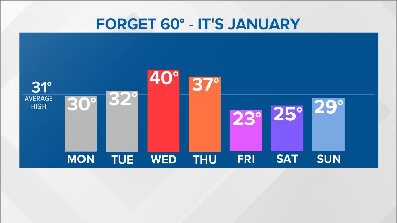
Monday looks like a relatively quiet day, bringing partly cloudy skies with high temperatures in the upper 20s to Maine. A handful of flurries are possible late Monday night and into Tuesday morning, but they likely will not have much of an impact on the region.
Tuesday is another quiet, colder day. High temperatures top out in the low 30s. Some clouds and a stray flake or two move through Tuesday evening or early Wednesday morning. Again, impacts look minimal.
Wednesday stays pretty quiet. Clouds start to move in through the day, ahead of our next potential system. Highs actually jump up into the low 40s Wednesday with a few breaks of sunshine. It should be a nice day. Mostly cloudy skies are in the cards overnight Wednesday.
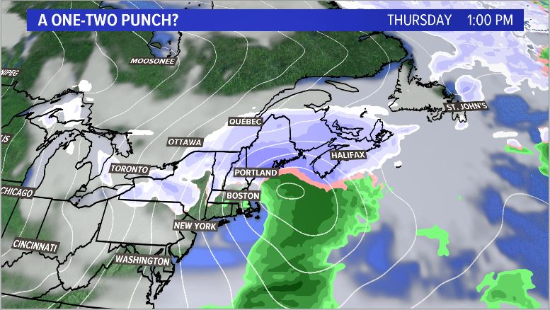
A couple of weather models are hinting at potential for a storm on Thursday. This could result in snow showers inland with some mixing at the coast. It’s a bit too far out right now to say anything concrete, but expect some activity late in the work week. This will be accompanied by a blast of Arctic air. It’s going to be cold Friday and Saturday.
Comments are no longer available on this story