

The first accumulating snow of the 2020/2021 winter season is possible Thursday night.
All of the ingredients are there: anomalous cold air, moisture and showers that move through overnight when it’s the coldest. The one thing missing is the ideal storm track, though that track is not out of the picture just yet. Let me explain.
NEWS CENTER Maine
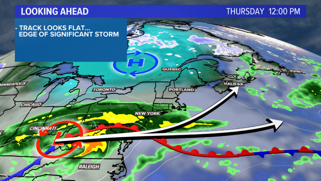
The remnants of what is currently Hurricane Zeta will pass through the mid-Atlantic on Thursday. As the storm moves north, cold high pressure from Canada slides south into Maine. This accounts for all the ingredients listed above: the cold, the storm and the moisture.
Cold air and moisture spell snow for early Friday morning. NEWS CENTER Maine
The storm track is still in question, though. Since the pattern looks fairly flat, the storm will move more to the east than to the north. With a track like this, southwestern Maine ends up on the fringe of the storm.
NEWS CENTER Maine
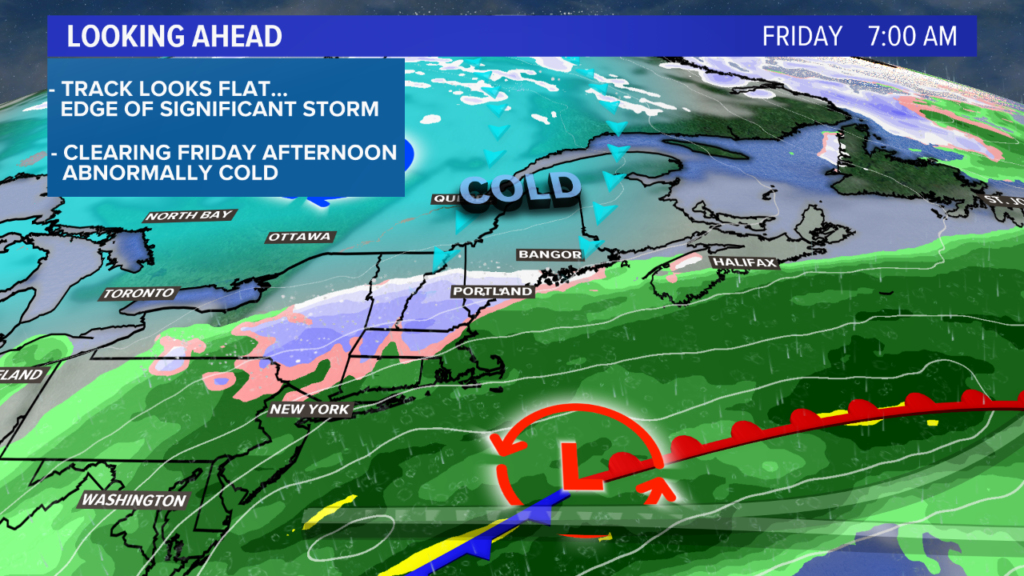
Rain precedes the snow on Thursday night. As the colder air mixes in and the storm moves east, expect a quick change to snow. The snow showers look to wrap up fairly quickly, too, so that helps with the forecast for lower totals and lesser impacts.
NEWS CENTER Maine
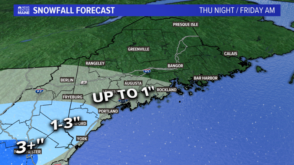
Forecast totals call for up to an inch of snow from Camden to Rangeley and everywhere in between, including Lewiston and Augusta. The coastal plain from Kittery to Portland and along the midcoast will also see about an inch. Areas north and east of this region will not see accumulating snow, though a few flurries may fall.
Interior York County will be the bull’s-eye locally, with 1 to 3 inches of snow expected. Some locally higher elevations could even get closer to 4 inches. The snow will likely be wet and heavy.
These totals put Maine on the edge of more significant impacts. Since the trees are still holding their leaves, it only takes about 4 inches of wet snow to start bringing down tree branches and power lines.
Currently, the best chance to hit the 4-inch or higher mark is over western New Hampshire and into Massachusetts and Vermont. Since the storm is still a day and a half out, though, it needs to be watched closely. A slight shift north in the track could result in higher totals here.
NEWS CENTER Maine
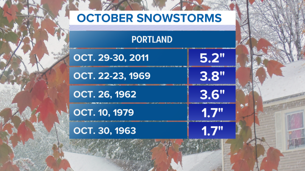
As far as snow in October goes, it’s not something that happens all that frequently. Statistics from the Portland Jetport show the Halloween Nor’easter of 2011 as the biggest snow event on record. The jetport registered 5.2 inches of snow from that storm.
Should this storm shift slightly north, it’s a real possibility that it ends up on this list of October snow events.
NEWS CENTER Maine
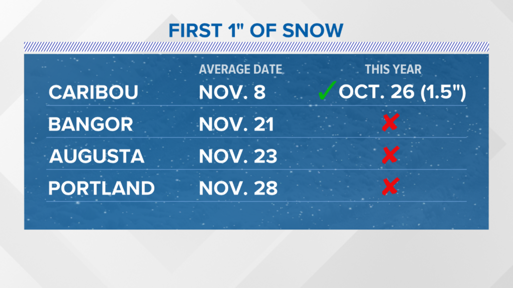
Normally, the first inch of snow in Portland does not happen until the last week of November. Other cities are Maine are a bit earlier. The only area that has registered its first inch already this year is Caribou.
There is a real chance that Portland will be the second city on this list to see an inch of snow this year. Given the forecast trends for a milder stretch starting around Nov. 4, it could be a while until Bangor and Augusta get their first accumulating snow.
For more forecast information follow me on Twitter. I will be providing frequent updates on the forecast should anything change.
Send questions/comments to the editors.

Comments are no longer available on this story