
It’s not too often that the biggest weather models have significant differences when you’re 36 to 48 hours out from a storm, but that’s the game we’re playing with this one.
On the bright side, imperfect weather models are my job security. Well, that, and Portland Press Herald allowing me to write these weather columns.
I’ve been following closely all week long. I’m pretty confident that the majority of Maine will see fairly significant snow on Saturday.
It’s time to start prepping for snow now. Also, keep an eye on the wind gusts. Strong wind could cause some isolated outages along the coast.
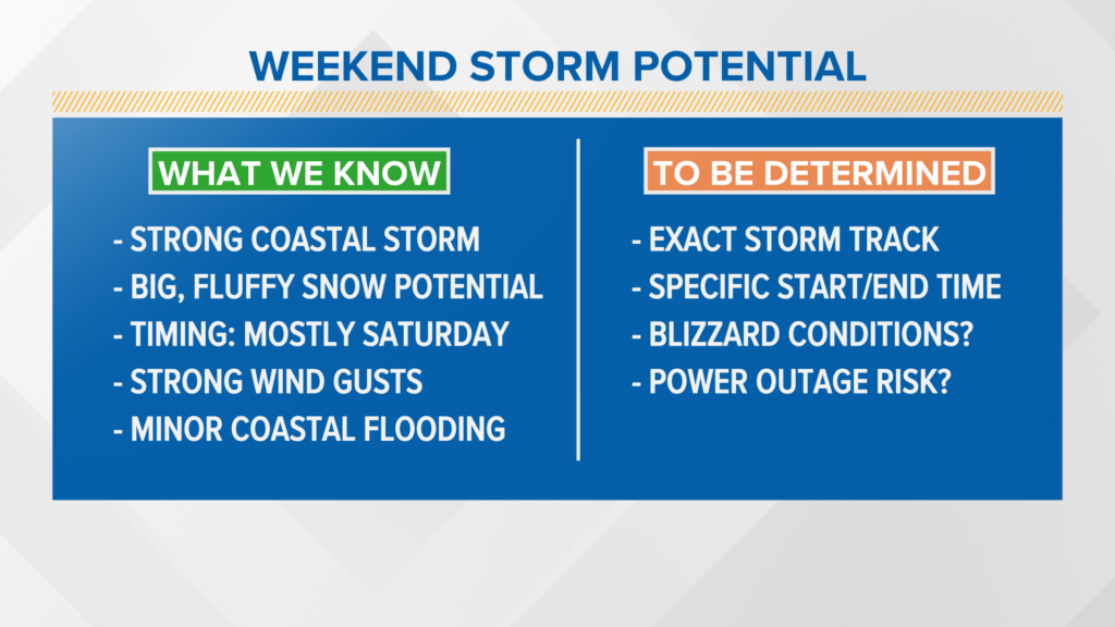
What we know
There is a large, strong storm system that will form off the Carolina coastline on Friday.
It will move north, affecting New England early Saturday and lasting through the day.
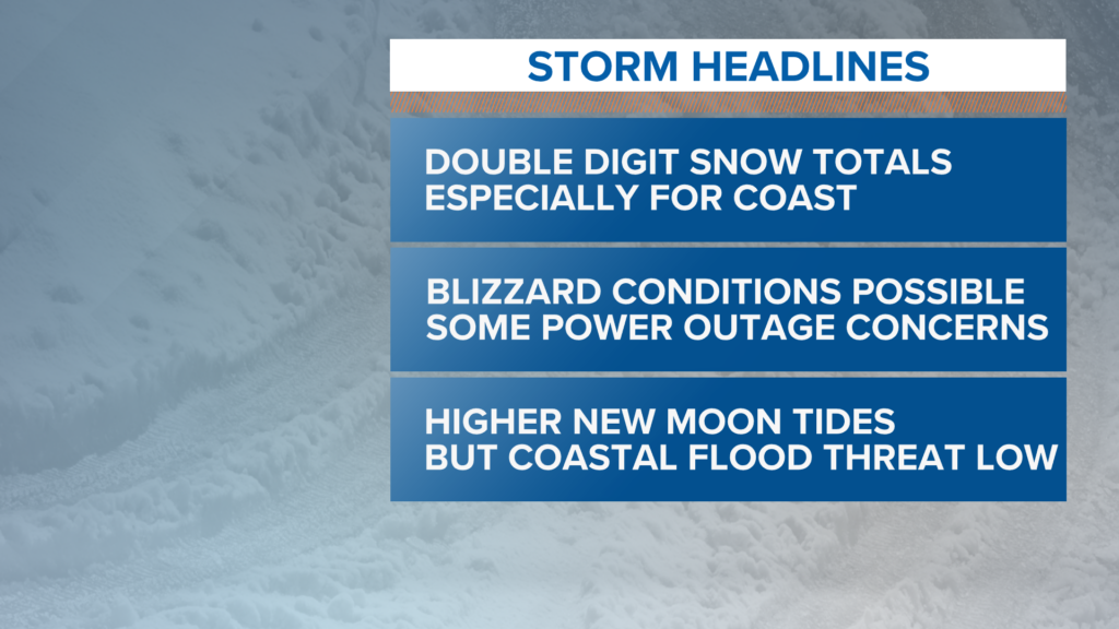
The cold air this storm has to work with will favor light, fluffy snow. There are increasing signals that the coast will likely end up with up to a foot of snow. A few pockets may even end up with more.
Wind gusts will be strong, coming out of the northeast. Gusts will generally be below 45 mph. Isolated power outages are possible.
Coastal flooding is less of a concern, since high tide does not coincide with the strongest wind gusts.
What we don’t know
The exact track of this storm is still being determined. Some shifts in snowfall forecasts are possible, though, at this point, I expect those shifts to be fairly small.
While it looks most likely that the storm will not start until early Saturday, the specific start times are not quite figured out yet. We are becoming more confident that most of the snow will be wrapped up by Sunday morning.
Blizzard conditions are independent of snowfall totals, but fluffy snow and strong wind gusts could certainly lead to blowing snow. For now, that’s yet to be determined, but I’d watch for blizzard conditions Down East.
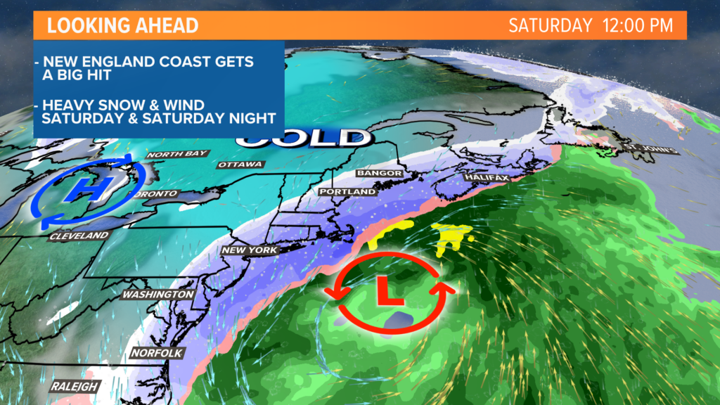
The issue with this forecast has always been the “wobble” factor in the storm track. A slight shift west or east means the heavy snow band will shift, which is what makes the forecast challenging.
It also will affect start and end times, so expect that graphic to make its return on Friday once the storm finally forms.
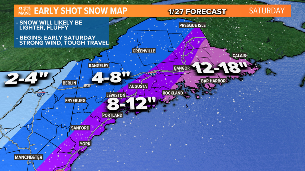
There have been some shifts here, most notably breaking up the original 10- to 20-inch range.
As models and current observations continue to hint at an eastern storm track, it makes the most sense to shift the bullseye of the highest totals to areas east of the Penobscot River.
Still, southwestern Maine is in the 8- to 12-inch range. Expect around a foot near Bangor, if not a little more.
Western Maine and the mountains will end up with 4 to 8 inches of fluff.
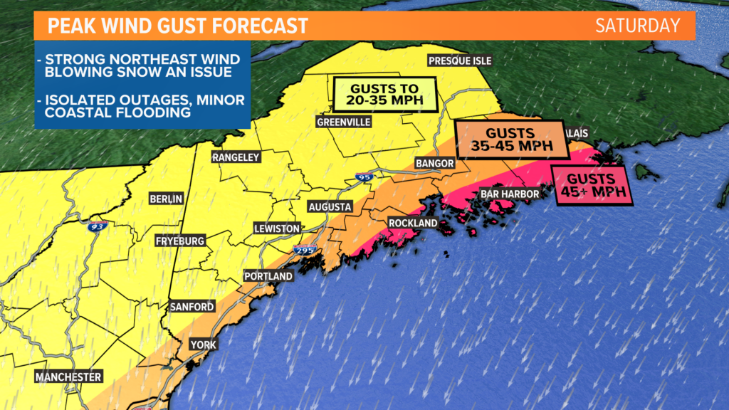
The strongest gusts will also be Down East and along the midcoast, where gusts could reach or exceed 45 mph. The entire coast could see wind gusts near 40 mph, though.
Inland areas will still be breezy, but not as gusty as the coast. Expect gusts in the 20-35 mph range.
Isolated power issues are possible, but the bigger story will be blowing snow.
Here’s one last “one-stop-shop” for storm info. While this is a good outline, expect even more specifics on Friday.
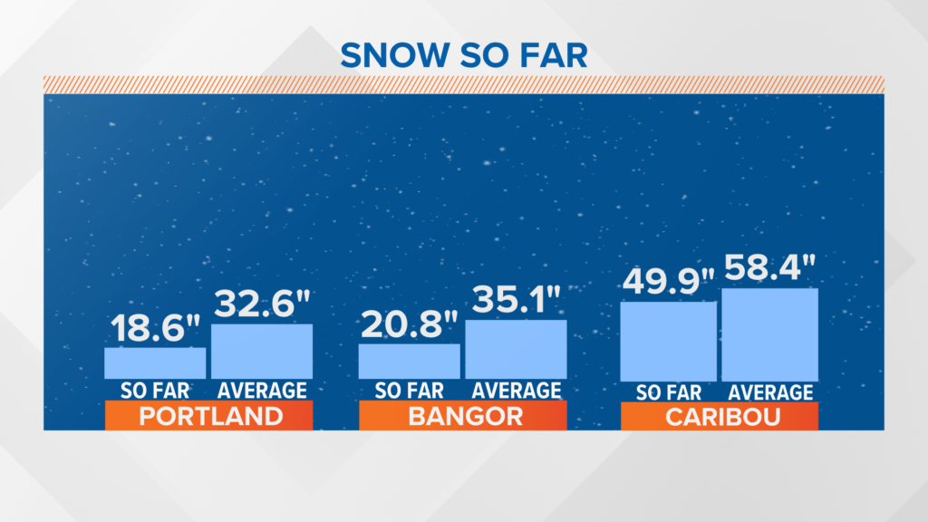
In case you’re keeping track at home, we have been running below average for snow this season.
Portland and Bangor are both roughly half of where they normally would be, and this storm will help bring seasonal totals close to normal.
Oh, and don’t look now, but Wednesday could be back into the 40s. Talk about a roller coaster!
See you again tomorrow with another update.
Mike Slifer, @MikeSliferWX
Comments are not available on this story. Read more about why we allow commenting on some stories and not on others.
We believe it's important to offer commenting on certain stories as a benefit to our readers. At its best, our comments sections can be a productive platform for readers to engage with our journalism, offer thoughts on coverage and issues, and drive conversation in a respectful, solutions-based way. It's a form of open discourse that can be useful to our community, public officials, journalists and others.
We do not enable comments on everything — exceptions include most crime stories, and coverage involving personal tragedy or sensitive issues that invite personal attacks instead of thoughtful discussion.
You can read more here about our commenting policy and terms of use. More information is also found on our FAQs.
Show less