


Damian Brady is one of the University of Maine researchers working with NASA on its PACE satellite mission that is collecting data about microscopic organisms in the ocean. He is hoping to use the data to help determine the best places in the Gulf of Maine for various forms of aquaculture. Photo courtesy of the University of Maine
Two University of Maine researchers are betting on the smallest microorganisms in the ocean to help study the biggest issue facing Maine’s coast: climate change. And they aim to do it from space.
Oceanography professor Emmanuel Boss and Damian Brady, acting director of the Darling Marine Center, are working with NASA on its PACE satellite, which launched last month and will orbit the planet for three years.
The satellite is using tiny pieces of algae to collect the most detailed data on record about the color and health of the ocean. Boss said that information will help scientists study changes on a global scale.
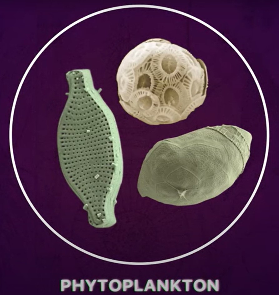
Enlarged views of different kinds of phytoplankton. These microscopic creatures that drift and float near the ocean’s surface are helping scientists study climate change. Image courtesy of NASA’s Goddard Space Flight Center
“When we’re trying to study climate change, having data in only the places where we have (research) boats is just not sufficient to be able to generalize about the whole ocean,” said Boss, who has worked on the project for almost 20 years and helped develop the algorithms it uses to gather and validate information.
But the data PACE is collecting could also have a range of impacts close to home, from helping identify the best areas in the Gulf of Maine for oyster and scallop farming to predicting the movements of right whales.
The satellite’s sensors gauge the color of the ocean by measuring how the sun interacts with pigments found in different kinds of phytoplankton. These microscopic organisms, which float and drift near the ocean’s surface, are the base of the marine food chain.
Understanding which kinds are congregating in different areas can point to where fish and mollusks will go to eat. It can also help spot toxic algae blooms.
EXPANDING AQUACULTURE
Brady is excited to use the research to help select sites for aquaculture.
“We are going to have almost daily hyperspectral images of the Gulf of Maine moving forward, which is incredible,” Brady said. “You stack enough images of the Gulf of Maine over time and you get this very dynamic picture.”
John Herrigel of Maine Oyster Co. in Phippsburg inspects his oyster farm in January 2021. A NASA satellite mission could help locate the best places to set up oyster farms in the Gulf of Maine. Shawn Patrick Ouellette/Staff Photographer, file
This is increasingly important as climate change threatens some of Maine’s traditional fisheries, Boss said.
“(Aquaculture) is a great way to diversify the economy of Maine in a time of uncertainty,” he said.
Simply identifying which phytoplankton species are present in a given area can have a host of implications for aquaculturists. For example, for farmers in Maine’s almost $11 million oyster industry, the data can highlight species that oysters like to eat – or species that prefer certain temperatures oysters might not like.
It can also aid sections of the industry still getting up and running, such as scallop farming. Maine has had a lucrative wild-caught scallop fishery for decades, but farmers are still working to make scallop aquaculture viable on a commercial scale.
A SpaceX Falcon 9 rocket carrying NASA’s PACE spacecraft launches from the Cape Canaveral Space Force Station in Florida at 1:33 a.m. on Feb. 8. Photo courtesy of NASA
Maine scallop farmers harvested about $580,000 worth of meat in 2023, a more than fivefold increase over the year before. Brady thinks data from PACE could help that grow further.
“It’s not too dissimilar to the beginning of the oyster industry. There’s a lot of people trying to figure out the right methods, the right husbandry practices, the right site,” he said.
Scallops prefer colder, more open water than oysters, which would make possible sites easier for the PACE satellite to pinpoint.
“Scallops are a really good target because these new satellites, while they’re hyperspectral and they’re amazing, they’ll be pretty coarse resolution. It’ll be a pretty big chunk of the ocean it looks at so it’s not going to be good up in estuaries” where oysters thrive, he said. “(The resolution) is going to be good in the Gulf of Maine and scallops are probably the kind of creature that is going to need to be in colder open water like that.”
RIGHT WHALES AND LOBSTER
Brady and Boss believe studying phytoplankton can also help scientists understand two other species whose intertwined futures carry great weight for Maine’s economy: lobster and the North Atlantic right whale.
Emmanuel Boss, an oceanography professor at the University of Maine, has been working on NASA’s PACE satellite mission for 20 years. Photo courtesy of the University of Maine
Lobstermen are facing strict regulations designed to help protect the critically endangered whale. The whales, thought to number fewer than 340 worldwide, are vulnerable to getting entangled in the veritable wall of rope in the water from the state’s iconic fishery. But Maine lobstermen contend they’re not seeing right whales in Maine waters and have routinely pushed for regulators to show more and better data about the whales’ movements.
Climate change is pushing lobsters farther off-shore in search of colder water. That colder water is also ideal for Calanus finmarchicus, the zooplankton of choice for the right whale, Brady said.
“A lot of the future of the lobster industry is going to be about how well we model North Atlantic right whales,” he said. “Can we use the enhanced phytoplankton data to predict where Calanus finmarchicus are going to be in the future? These will be better phytoplankton layers than we’ve ever had before.”
Brady also suggested the data could be used to study the phytoplankton before and after the installation of offshore wind farms. Dam removal could also be studied, Boss said. Removing dams affects the turbidity of water and researchers could examine how that impacts Atlantic salmon.
“It’s hard for me to think of a (marine) application where this doesn’t come into play,” Brady said.
Boss and Brady expect the satellite to start transmitting usable photos within the next few weeks.
“Oftentimes we’ll see on the news something happening with NASA and we can’t connect it locally to what’s happening in Maine,” Brady said. “It’s just a tremendous opportunity.”
Send questions/comments to the editors.

Comments are no longer available on this story