
Officials and forecasters have been keeping a close eye on a large ice jam on the Kennebec River in northern Somerset County, although they say the risk of impacts like flooding is relatively low at this point.
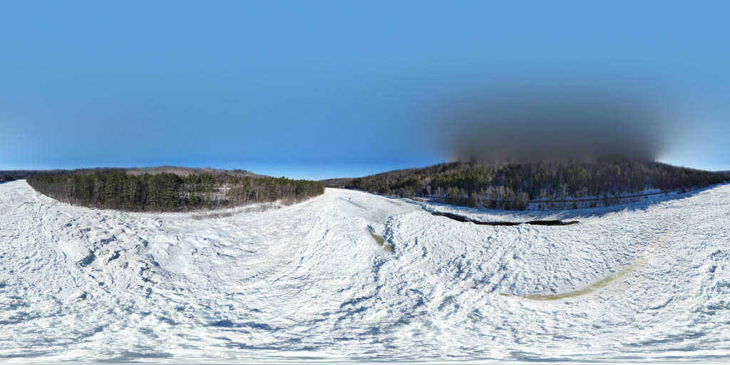
The jam has piled up ice along approximately 3 miles of the river in Caratunk, about 40 miles north of Skowhegan, said Sara Bickford, director of the Somerset County Emergency Management Agency.
Ice jams are common in the area and throughout Maine’s rivers. But the size and timing of this one is notable.
Bickford said that when Liz Caruso, a Republican state representative from Caratunk and the town’s first selectman, first contacted the agency earlier this month, the ice was nearly at the height of U.S. Route 201 in one area near The Forks town line. A video Caruso posted on social media circulated widely.
“The biggest concern right now is that water has nowhere to go because of the ice diverting it, so it will then encroach into 201, potentially flood the road or cause infrastructure damage to the road,” Bickford said in a phone call Thursday. “Or, if and when the ice jam lets go, all of that force could erode some of the banks there as well.”
The ice jam appeared to be caused at least in part by river flows controlled by upstream hydroelectric stations, along with cold temperatures, Bickford said.
“Typically, we see ice jams with a lot of freeze-thaw events,” she said, “and we didn’t have that.”
Brookfield White Pine Hydro, a subsidiary of Brookfield Renewable, has been working to alleviate impacts from the ice jam by adjusting dam releases upstream, spokesperson David Heidrich said. Among other hydroelectric projects, the company operates Harris Station dam on the Kennebec River northeast of The Forks, and Flagstaff Lake dam, which controls the Dead River, a Kennebec River tributary.
“(Brookfield) is actively monitoring and adjusting generation and flows from Harris Station Dam and Flagstaff Lake with the goal of developing a larger channel through the ice jam and alleviating, to the extent possible, any potential flooding issues,” Heidrich said in a statement Wednesday.
“We continue to monitor conditions closely and coordinate with partners to manage river flows to the extent we are able,” he continued. “Regardless of the proactive steps taken by (Brookfield), it is important to note that any unexpected shift in the ice pack has the potential to change conditions along the river.”
The Maine Department of Transportation, along with Somerset County EMA and local officials, is monitoring impacts on U.S. Route 201, which largely runs parallel to and at points directly next to the river.
The department is ready to respond if there are impacts to the highway, spokesperson Andrew Gobeil said via email Thursday. Over at least the last seven years, Maine DOT staff does not recall any time Route 201 flooded because of ice jams, he said.
“While ice jams are not uncommon in this area, the primary difference this year is the earlier timing,” Gobeil said. “Otherwise, conditions are consistent with what we have experienced in previous years.”
Stephen Baron, a meteorologist with the National Weather Service regional office in Gray, said the agency is monitoring flood risks too.
So far, cold temperatures have meant no significant movement of ice on the Kennebec — which Baron said is where flooding concerns usually arise.
A moderate warmup forecast for the next several days is not expected to have a major impact, he said.
“It’s not like it’s going to be a rapid melt situation,” Baron said in a phone call Thursday. “It’s going to be gradual enough that it shouldn’t cause any issues.”
Persisting drought conditions may also provide a buffer when the ice thaws, as rivers have more capacity, according to Baron.
The ice jam in Caratunk is the only one reported in the Gray office’s area in Maine, which includes the southern, western and central parts of the state. The weather service uses satellite imagery to monitor ice jams, but relies primarily on trained spotters, including local emergency managers, for accurate reports, Baron said.
“Overall, the flood threat has been low,” Baron said. “And, barring any kind of extreme event, we should see that persist into the spring.”
We invite you to add your comments. We encourage a thoughtful exchange of ideas and information on this website. By joining the conversation, you are agreeing to our commenting policy and terms of use. More information is found on our FAQs. You can modify your screen name here.
Comments are managed by our staff during regular business hours Monday through Friday as well as limited hours on Saturday and Sunday. Comments held for moderation outside of those hours may take longer to approve.
Join the Conversation
Please sign into your CentralMaine.com account to participate in conversations below. If you do not have an account, you can register or subscribe. Questions? Please see our FAQs.